France: Le Vercors | DJI Mavic 2 Pro & GoPro Hero 5 Session and 7 Black
AIRVŪZ STAFF NOTE :
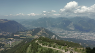
Contributor Matt38310 used a DJI Mavic Pro 2 and a GoPro Hero 7 to create this video from a trip to the foothills of the French Alps. The area filmed is called the Vervors Massif. It's one of the chain of mountains which run through southeastern Francs, forming a rough "C" starting just west of Lake Geneva. These are called the French Prealps, and the Vercors lie roughly in the middle of the chain. The highest Vercors peak is Grand Veymont, with a maximum elevation of about 2.35k meters (about 7.7k ft.).
- about 5 years ago
- 265 VŪZ
12 


- 8
- Report


BADGES THIS VIDEO HAS EARNED:

A return to my roots with close friends, where I lived for the first 12 years of my life before moving to Grenoble. Le Moucherotte (1901 metres) is the easternmost peak of the Vercors Massif and overlooks the city of Grenoble. The ski jumping event for the 1968 Winter Olympics was held here. The facilities are no longer in use. The eroded limestone of the Vercors Massif is spotted bare of vegetation as seen on the Trois Pucelles and the ridge facing Grenoble. Then the Vercors opens up before your eyes with Lans-en-Vercors, the plateau that was once a sea and Villard de Lans. It is then closed by the Gorge de la Bourne. Thanks for watching, I hope you enjoy it :-) Shot in Vercors, Isère, France July / August 2019 St Nizier du Moucherotte Les Trois Pucelles Lans-en-Vercors Villard-de-Lans Espace Villard de Lans Corrençon Gorge de la Bourne Pas de l'Ours / Rencurel
Up Next
Portugal: Sea, Surf and Sun (and Tennis) | DJI Mavic 2 Pro / GoPro Hero 5 Session & 7 Black

- Matt38130
- 596 VŪZ
11 - 10
- about 5 years ago
Moucherotte // FPV CINEMATIC // MAVIC 2 PRO

- Thibault_L
- 1.7k VŪZ
4 - 5
- over 1 year ago
Niederhorn - Burgfeldstand | DJI Mavic 2 Pro - Switzerland Hiking

- Paride Musci
- 1.4k VŪZ
24 - 17
- almost 6 years ago
Massif du Vercors - Cinematic FPV

- Elouan Gaudin
- 853 VŪZ
9 - 8
- about 1 year ago
Showreel 2015 DJI Phantom 2 + GoPro hero 4 black

- Falconskytech
- 1.5k VŪZ
26 - 15
- over 7 years ago
PROPRIANO CORSICA (AND ITS SURROUNDINGS) 4K

- Mamax
- 919 VŪZ
10 - 10
- almost 4 years ago
Winter Audit

- jimmac
- 878 VŪZ
19 - 12
- almost 7 years ago
DarkSide | FPV Cinematic

- Greco FPV
- 1.6k VŪZ
9 - 9
- over 5 years ago
Lord of the Rims

- Rocannon
- 1.2k VŪZ
12 - 7
- about 6 years ago
French wine region Bourgogne during fall season drone 4K

- al_drone71
- 693 VŪZ
5 - 4
- over 2 years ago