Interested In This Footage?
Pictures of Transilvania
AIRVŪZ STAFF NOTE :
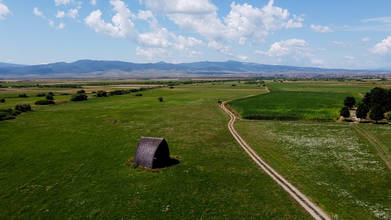
Check out these fantastic drone views of Romania's Transylvania region, compliments of AirVuz contributor and pilot Gergel Osztie. The video opens with shots of the Bucegi Mountains, part of the Southern Carpathian chain which forms Transylvania's natural southern boundary. At around the 1:15 mark, you'll see one of the towns of Gheorgheni in Harghita County. At about the 1:30 mark, you'll see the old city of Brasov, one of Transylvania's most important cultural centers. Another highlight (at 2:08) is the fortified church of Prejmer.
- over 2 years ago
- 1.2k VŪZ
12 


- 10
- Report
BADGES THIS VIDEO HAS EARNED:

My video shows a little bit of the taste of Transilvania! Transilvania is a highly diverse region, in nature, ethnicity and history as well. You can see parts of Souther-Transilvania, which used to be inhabited by Saxons. The remainings of their rich culture can be seen in the fortified churches of Prejmer (Prázsmár), which is a UNESCO World Heritage Site and the wonderful church of Harman (Szászhermány/Honigberg). The historical centre of Brasov (Brassó) also presents great architectural sights. The Bucegi mountains (Bucsecs) is the highest and most vivid part of the Carpathian mountains, which sorround Transilvania. You can find peaks up to 2500 meters. The Gyergyó basin is inhabited by ethnic Hungarians, who preserve their religion, language and way of living. (The music is a piece of Bartók, based on the antic hymn of Szeklers in Transilvania.)
Up Next
Budajenő I Beautiful Hungarian Village I DJI Mavic Mini

- Gergely Osztie
- 1.1k VŪZ
18 - 29
- over 3 years ago
Between autumn and winter in Romania.
- danmir12
- 534 VŪZ
12 - 10
- over 3 years ago
MOTION REEL 2019

- Eaglewood Pictures
- 1.4k VŪZ
29 - 24
- over 4 years ago
The Hungarian Sea / Balaton

- superstar pictures
- 1.1k VŪZ
14 - 11
- over 4 years ago
Showreel 2016 in 4K, by Drone-Pictures (France)

- Drone-Pictures
- 768 VŪZ
12 - 8
- about 7 years ago
Bringing Pictures To Life

- Sandrine Hecq
- 1.4k VŪZ
27 - 25
- over 6 years ago
ÜBERLINGEN am Bodensee - UBERLINGEN at Lake Constance in 4K - UHD

- New Entertainment ...
- 924 VŪZ
17 - 14
- over 3 years ago
FROZEN LAPLAND
- Eaglewood Pictures
- 1.5k VŪZ
12 - 11
- about 3 years ago
15 Minutes of Winter
- Eaglewood Pictures
- 1.1k VŪZ
16 - 15
- about 4 years ago
Amazing View of the Cotter Dam

- Matteo Pictures
- 1.9k VŪZ
24 - 16
- about 7 years ago