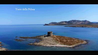
The Ancient Watchtowers of Stintino
- over 1 year ago
- 128 VŪZ
5 


- 6
- Report
The Torre della Pelosa is a tower that is part of the complex of fortified structures which, from the early Middle Ages to the mid-nineteenth century, formed the defensive, sighting and communication system of the Sardinian coastal strip. It is located on an islet between Isola Piana and Capo Falcone right at the entrance to the Asinara strait, a strategic position for controlling the traffic of boats that headed from the "outside sea" to the low and sandy coast of the gulf. dell'Asinara, easily violated in the event of an assault on the coastal communities of the area. It is in visual contact with the towers of Isola Piana and Capo Falcone. The tower takes its name from the nearby beach originally called "Sa palosa", probably due to the presence of sea straw (algae) which is deposited in abundance. It has a truncated cone shape, a base diameter of 16 m, a height of 10 m and a thickness of the perimeter wall of about 2.5 m. It is built with the local stone, schist, and is located at an altitude of three meters above sea level. The hatch is located six meters above the ground and, as with most of the coastal towers of Sardinia, access to the tower was done with the aid of rope or rung ladders which, in case of danger, could be easily retracted. The room has a mushroom vault supported by a central pillar and is divided into three rooms, each of them equipped with a slit; to the left of the hatch, created inside the perimeter wall, there is a narrow and steep staircase which leads to the terrace or parade ground. Above the terrace was the so-called "crescent", a light semicircle-shaped structure made of tiles and reeds, which rested on the parapet, built to shelter soldiers and ammunition. The Pelosa tower was built with certainty before 1578, the date on which, in a document signed by the viceroy De Moncada, there is already mention of the need to intervene for repairs. Other documents report that the typology of the tower was of the type de armas or gagliarda, that is of heavy defense and that the garrison in garrison was formed by the commander, the alcaide, an artilleryman and three or four soldiers who had a compound armament at their disposal. by three large-caliber guns, a gun and some rifles. The tower was abandoned in 1846, four years after the suppression of the Royal Administration of the towers, the institution that managed the island's coastal defense system. The Torre della Finanza, or Piana Island Tower, is a coastal tower built in the 16th century. The structure (not to be confused with the tower of Punta Imbarcatogio located on the southern side) is located on the northern side of Isola Piana, administratively belonging to the municipality of Porto Torres. diameter of 16 m. About 18 m high, it rises on two levels above ground, the lower one covered by a domed vault and the upper one closed by a lowered vault. The Torre delle Saline is located on the seashore, at the north end of the homonymous beach, has two floors and is built with local stone, schist. It has a conical shape, a height of 12.5 m and a diameter of 11.80 m; the thickness of the wall is two meters. The hatch, for safety reasons, is located four meters above the ground and, as in most of the coastal towers of Sardinia, access to the fort was done with the aid of rope or rung ladders which in case of danger they could be retracted quickly. The first floor is a bombproof chamber of 7.30 meters in diameter with a large pillar in the center that supports the attic, once in the shape of a mushroom. Three thrones arranged in a radial pattern facilitated the ventilation of the environment and allowed a certain control of the surrounding area. A ladder led to the second floor, a room with a domed vault also with a central pillar, while access to the parade ground takes place thanks to a narrow staircase created inside the perimeter wall that ends with a hatch, probably originally surmounted by a masonry sentry box to protect against atmospheric agents. Presumably above the terrace there was the so-called "crescent", a light structure in the shape of a semicircle made of tiles and reeds, which rested on the parapet, built for the purpose of sheltering soldiers and ammunition. During a restoration, the roof of the terrace was demolished and rebuilt in a different way from the original. The tower of the Saline was classified as a strong tower (de armas) that is of heavy defense and therefore could boast a garrison formed by an alcaide, who was the commander, and five or six soldiers including gunners and soldiers. They had at their disposal an armament consisting of two 2x4 caliber guns, three guns and five rifles. From the Relaçion de todas las costas maritimas de lo Reyno de Cerdeñadel drawn up on behalf of King Philip II of Spain by the lord and captain (podestà) of Iglesias Marco Antonio Camos, the tower was built in 1572. The Torre del Falcone or Capo Falcone tower located on the top of the homonymous promontory, at 189 m a.s.l., thanks to the excellent view it enjoys, dominates an exceptional horizon that embraces the Gulf of Asinara (including the island itself) and almost all of the Nurra. It is in visual contact with the towers of Trabucado, Pelosa, Isola Piana, Saline, Porto Torres and Frigiano. Built with shale stones recovered on site, the tower has a truncated cone shape, with an external diameter of 9.5 meters, a height, from the base to the pavement, of 8 meters and perimeter walls approximately 1.5 meters thick. . The entrance, located four meters above the ground, takes place thanks to an external staircase; this leads into a circular chamber with a diameter of 5.6 meters in which a central pillar supports the domed vault; radially at the entrance there are two thrones or loopholes. A narrow and steep staircase close to the perimeter wall leads to the terrace or parade ground; a masonry sentry box protects the hatch from atmospheric agents. Above the terrace there was the so-called crescent, a light semicircle-shaped structure made of tiles and reeds, which rested on the parapet, built for the purpose of sheltering soldiers and ammunition. The Falcone tower appears for the first time in the map by the military engineer Rocco Cappellino, sent to Sardinia by the emperor Charles V in 1552. From this we can determine the year of construction which most likely was 1577. Considering the strategic position, more than a strong tower or a senzilla (this is how defense towers were defined) it can be considered a torrezilla, that is a sighting and signaling post. The garrison consisted of two soldiers who had two rifles and two guns at their disposal.
Up Next
Sardinia, Stintino - Asinara Island Naturalistic and Marine park

- Marco Miele
- 1.4k VŪZ
10 - 18
- almost 2 years ago
Dronatic Year 2022, relaxing audio and video
- Marco Miele
- 779 VŪZ
5 - 11
- over 1 year ago
Sardinia, July 2023
- Marco Miele
- 1.1k VŪZ
9 - 15
- 9 months ago
La Pelosa - Stintino (Sardinia Italy)

- azzurro1
- 1.1k VŪZ
15 - 13
- over 4 years ago
La Pelosa (Stintino) One Day In Paradise (4K)

- chir72
- 2.6k VŪZ
22 - 17
- about 7 years ago
Umbria - Passignano sul Trasimeno and surroundings
- Marco Miele
- 1.1k VŪZ
9 - 14
- over 2 years ago
The Castle of Sestola
- Marco Miele
- 1.1k VŪZ
15 - 18
- over 4 years ago
Personal tribute to Marciana Marina - Elba Island -
- Marco Miele
- 1.1k VŪZ
14 - 21
- almost 4 years ago
Regional Park of Gessi Bolognesi and Calanchi dell'Abbadessa
- Marco Miele
- 789 VŪZ
12 - 18
- over 3 years ago
San Benedetto del Tronto - Summer 2020
- Marco Miele
- 1.1k VŪZ
8 - 16
- over 3 years ago