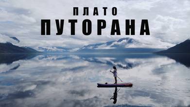
ARCTIC YOUTH EXPEDITION TO PLATO PUTORANA (RUSSIA)
- over 4 years ago
- 139 VŪZ
5 


- 5
- Report
On the territory of the Krasnoyarsk Territory, on the border with the Taimyr Peninsula, in the permafrost there is one of the most poorly studied and inaccessible regions of our country - the Putorana Plateau. The area of the plateau is comparable to that of Great Britain. You can get here from Norilsk, but only by water or air. The first Russian explorer to scientifically describe the plateau in 1844 was Alexander Middendorf. In memory of him, in 1902, they wanted to call the massif the Middendorf Ridge. The modern name is of local origin, and its real meaning has not been fully understood. According to one of the versions, the plateau is named after the Putoramo lake located in its center, which is now called Khantaysky. There are also two translations of this word from Evenk. Putorana can be formed from "kutarama", which means "swampy" or "peteromi" - "cloudy". About 250 million years ago, a series of eruptions began at this site, which lasted several tens of millions of years. At the same time, there have never been volcanoes on the plateau. The magma emerging from the ground solidified layer by layer, forming flat basalt mountains called trapps. Their maximum height is about 1700 meters. During the eruptions, the plateau was at sea level, but about 140-160 million years ago, its central part began to rise. The process lasted several million years, and during this time, faults formed in the basalt. In their place of faults, lakes, canyons and waterfalls appeared. Basalt mountains formed by lava flows are found throughout the Central Siberian Plateau. But the Putorana plateau is the only large area that is completely composed of basalt. It is the second largest trap plateau in the world. Only the Deccan plateau in India is larger.
Up Next
AERIAL FOOTAGE 🚁 DUDINKA (KRASNOYARSK REGION)
- VadimUshKa
- 1.2k VŪZ
4 - 2
- about 4 years ago
Sea Unicorn. Arctic. Franz Josef Land. Narwhal Expedition.

- Timelab.pro
- 2.1k VŪZ
19 - 17
- about 2 years ago
Aerial Footage. Nizhny Novgorod (Russia)
- VadimUshKa
- 1.3k VŪZ
14 - 11
- almost 6 years ago
Aerial Footage. Irkutsk (Russia)
- VadimUshKa
- 1.5k VŪZ
14 - 12
- almost 6 years ago
VELIKY NOVGOROD
- VadimUshKa
- 701 VŪZ
8 - 5
- over 3 years ago
CITY OF CHEKHOV 🏡 FAIRY WINTER IN MOSCOW REGION
- VadimUshKa
- 703 VŪZ
3 - 3
- almost 4 years ago
WINTER BAIKAL ❄️ (LISTVYANKA, OLKHON)
- VadimUshKa
- 1.9k VŪZ
3 - 3
- over 2 years ago
LAKE BAIKAL (SIBERIA, RUSSIA) | RELAX MUSIC 🎵
- VadimUshKa
- 882 VŪZ
10 - 8
- over 2 years ago
Samara Region (Samara, Togliatti, Shiryaevo, Bogatyrskaya Sloboda)
- VadimUshKa
- 761 VŪZ
6 - 3
- over 4 years ago
Aerial Footage. Moscow №1
- VadimUshKa
- 1.1k VŪZ
14 - 12
- almost 6 years ago