Aerial Mapping in Lagos, Nigeria
- almost 8 years ago
- 228 VŪZ
7 


- 1
- Report
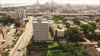
This aerial drone survey was conducted at the former Lagos State School of Nursing in Ikoyi, Lagos, Nigeria. We offered our client REAL-TIME mapping outputs which included a 3D site model, orthomosaic map, and an elevation map. This process significantly reduced the time needed for their pre-construction survey and inspection. The data we provided enabled them to perform distance and area measurements, analyze volumetric measurements, and more.
Up Next
Autoplay
Lekki Conservation Center - Lagos, Nigeria

- GlobalAirMedia
- 1.4k VŪZ
9 - 10
- over 5 years ago
Aerial Pursuit: FPV Drone Captures Roller Skater's Journey in Lagos

- Semostev Media
- 1.0k VŪZ
6 - 12
- about 2 months ago
Akwa Ibom International Soccer Stadium
- GlobalAirMedia
- 1.8k VŪZ
26 - 19
- over 8 years ago
Ellicott City 3D Mapping of Flood Damage
- GlobalAirMedia
- 595 VŪZ
7 - 2
- over 7 years ago
Beautiful sunset footage in New York City!
- GlobalAirMedia
- 3.8k VŪZ
24 - 21
- over 7 years ago
Baltimore Afternoon Jam
- GlobalAirMedia
- 730 VŪZ
10 - 9
- over 5 years ago
PORTUGAL 2023 | A Relaxing Cinematic Drone Edit | Lisbon, Sintra, Lagos

- RStory
- 1.2k VŪZ
4 - 4
- about 1 year ago
Algarve From Above - 4K drone footage

- Enrico Pescantini
- 961 VŪZ
17 - 12
- over 5 years ago
Scenes from Greenwich Park, London, UK by GlobalAirMedia.com
- GlobalAirMedia
- 1.3k VŪZ
16 - 16
- over 6 years ago
Downtown Baltitmore Footage
- GlobalAirMedia
- 844 VŪZ
9 - 7
- about 8 years ago