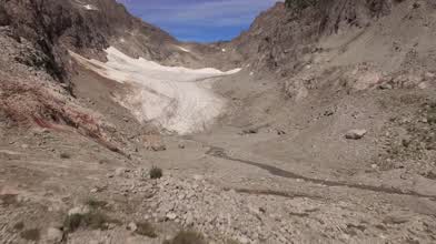
Blanca Lake and Columbia Glacier, Washington, USA from the air
- over 7 years ago
- 48 VŪZ
3 


- 2
- Report
This was definitely the hardest journey on foot I've taken to get a drone flight location- I ended up traveling between 12 and 13 miles with about a 4,000 foot elevation gain. In addition to the drone and control equipment, five Phantom 3 batteries never felt heavier! Because of the bright sunlight, an ND32 filter was used throughout and I still had shutter speed up at 1/80, which is a little higher than I like. That was to keep from blowing out the highlights, especially the Columbia Glacier. Blanca Lake is a glacial fed lake, which gives its blue-green color. The term for this is a "rock flour lake".
Up Next
Autoplay
Beautiful Sunset Aerial Views over Seattle Skyscrapers & Puget Sound

- SkyStudioWest
- 1.2k VŪZ
17 - 20
- over 3 years ago
Glaciers, Rivers & Lake. British Columbia

- SD Aérials
- 586 VŪZ
12 - 10
- over 3 years ago
Just Fly | FPV Freestyle

- 509FPV
- 864 VŪZ
6 - 4
- over 1 year ago
It took me 6 years to film this

- Aerial RC
- 959 VŪZ
6 - 12
- over 2 years ago
Swiss Icebergs (Valais, Switzerland) 🧊

- Kpax
- 534 VŪZ
10 - 8
- about 3 years ago
Across State Parks | Mavic Pro

- Feben Earth
- 1.1k VŪZ
13 - 18
- over 4 years ago
Caldera Blanca. Volcanoes from Lanzarote.

- WeiS PRoDuCTioNS
- 1.0k VŪZ
7 - 5
- about 2 years ago
Shakes Glacier in 4K

- Drone_Alaska
- 1.3k VŪZ
20 - 12
- over 5 years ago
Flying Over Sunset Seattle [FHD] Space Needle, Downtown, Waterfront
- SkyStudioWest
- 807 VŪZ
3 - 2
- almost 3 years ago
Zen time at Joffre Lakes

- Aerial Eye Visuals
- 2.8k VŪZ
53 - 47
- almost 7 years ago