Killiney Hill & Dalkey | Co. Dublin | Ireland
AIRVŪZ STAFF NOTE :
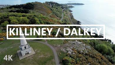
The southern end of Ireland's Dublin Bay is formed by two natural landmarks: Killiney and Dalkey Hills. Killiney Hill, the southernmost of the two, is crowned by an obelisk at its summit, which sits at an elevation of about 500 ft. (just over 150 meters) above the Irish Sea. In this drone video by AirVuz contributor and pilot ireland_from_air, you'll get an aerial tour of this area, including some nice shots of the obelisk. Note the fantastic views from these elevations of Dublin Bay as well as the mountains which lie in the interior.
- about 5 years ago
- 580 VŪZ
9 


- 7
- Report

BADGES THIS VIDEO HAS EARNED:

Killiney Hill (Irish: Cnoc Chill Iníon Léinín) is the southernmost of the two hills which form the southern boundary of Dublin Bay (the other being Dalkey Hill). Crowned by an obelisk, the hill is 153 metres high and has views over the surrounding areas: Dublin to the northwest; the Irish Sea and the mountains of Wales (on a clear day) to the east and southeast; and Bray Head and the Wicklow Mountains to the south. The hill was higher in the past but material was removed from the summit for the construction of the pier at Dún Laoghaire. Location: Killiney Hill / Ireland https://goo.gl/maps/aEoEZ4Dq8ogFogDRA –––––––––––––––––––––––––––––– Drone: DJI Air 2S - 5k 30fps –––––––––––––––––––––––––––––– Music: –––––––––––––––––––––––––––––– Track: Lovesight — DayFox [Audio Library Release] Music provided by Audio Library Plus Watch: https://youtu.be/PJdGPQigyMw Free Download / Stream: https://alplus.io/lovesight ––––––––––––––––––––––––––––––
Up Next
County Dublin | Volume One | Ireland
- Ireland from air
- 1.5k VŪZ
13 - 8
- almost 5 years ago
Killiney Hill | Co. Dublin | Ireland
- ireland_from_air
- 737 VŪZ
7 - 4
- about 5 years ago
Beautiful Ireland's Coastline 2021 | Cinematic Drone Footage 4K | DJI Air 2S
- Ireland from air
- 1.8k VŪZ
12 - 11
- over 4 years ago
Malbork Castle Poland, Mavic pro 4k

- Mark's Mavic 2
- 4.4k VŪZ
23 - 17
- almost 8 years ago
Mary McAleese Boyne Valley Bridge | Co. Louth / Meath | Ireland
- Ireland from air
- 1.8k VŪZ
18 - 12
- almost 5 years ago
Malahide | Co. Dublin | Ireland
- ireland_from_air
- 1.1k VŪZ
3 - 2
- almost 5 years ago
Cinematic Drone Video 4K - Drogheda Ireland

- UmairK.Official
- 1.0k VŪZ
8 - 7
- about 3 years ago
Portrane | Co. Dublin | Ireland
- ireland_from_air
- 671 VŪZ
2 - 1
- about 5 years ago
Rush | Co. Dublin | Ireland
- ireland_from_air
- 515 VŪZ
2 - 1
- about 5 years ago
Skerries | Co. Dublin | Ireland
- ireland_from_air
- 519 VŪZ
6 - 5
- about 5 years ago