Lough Owel | Mullingar | Co. Westmeath | Ireland
- over 2 years ago
- 231 VŪZ
8 


- 5
- Report
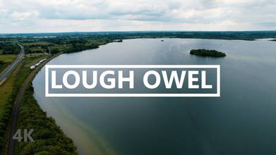
Lough Owel is a mesotrophic lough in the Midlands of Ireland, situated north of Mullingar, the county town of Westmeath. It has a maximum depth of 21 metres. Water from Lough Owel feeds the Royal Canal, a canal crossing Ireland from Dublin to the River Shannon. There are four main islands in the lough, the largest being Church Island, named because of the ruins of a church known as St. Loman's Oratory that used to be in the Parish of Mullingar. St Loman was a hermit on the island, where he was said to have subsisted on a diet of wild alexanders (Smyrnium olusatrum). The other three islands are Srudarra Island, Lady's Island and Carrickphilbin Island.The Viking chieftain Turgesius is said to have been drowned in Lough Owel by Máel Sechnaill mac Maíl Ruanaid in 845. Location: Lough Owel | Mullingar | Co. Westmeath | Ireland https://goo.gl/maps/fQzaFdSyVrDyPR5S6 –––––––––––––––––––––––––––––– Drone: DJI Air 2S - 5k 30fps –––––––––––––––––––––––––––––– Music: –––––––––––––––––––––––––––––– Song: Luke Bergs - Tropical Soul Music provided by Vlog No Copyright Music. Creative Commons - Attribution-ShareAlike 3.0 Unported Video Link: https://youtu.be/rQV9GDOc3Lo ––––––––––––––––––––––––––––––
Up Next
Mary McAleese Boyne Valley Bridge | Co. Louth / Meath | Ireland

- Ireland from air
- 1.6k VŪZ
18 - 12
- over 2 years ago
Magical Ireland

- Peter and Loki
- 1.0k VŪZ
16 - 12
- over 4 years ago
County Dublin | Volume One | Ireland
- Ireland from air
- 1.3k VŪZ
13 - 8
- over 2 years ago
St Patrick's Purgatory, Lough Derg, Ireland. Cinematic 4K Drone Footage.

- Mark's Mavic 2
- 657 VŪZ
12 - 9
- about 3 years ago
Lough Tay, The Guinness Lake. Ireland. Mavic 2 pro
- Mark's Mavic 2
- 1.7k VŪZ
31 - 21
- over 5 years ago
The Glory of Ireland

- Flying Films NY
- 1.2k VŪZ
19 - 15
- over 4 years ago
Beautiful Ireland's Coastline 2021 | Cinematic Drone Footage 4K | DJI Air 2S
- Ireland from air
- 1.6k VŪZ
12 - 11
- over 2 years ago
Film Reel 2019

- eireialcreations.ie
- 982 VŪZ
14 - 14
- almost 4 years ago
Carlingford and King John's Castle. Ireland. Mavic 2 Pro.
- Mark's Mavic 2
- 1.0k VŪZ
14 - 9
- over 5 years ago
Past in Present

- Drone photography ...
- 1.8k VŪZ
8 - 9
- over 1 year ago