Interested In This Footage?
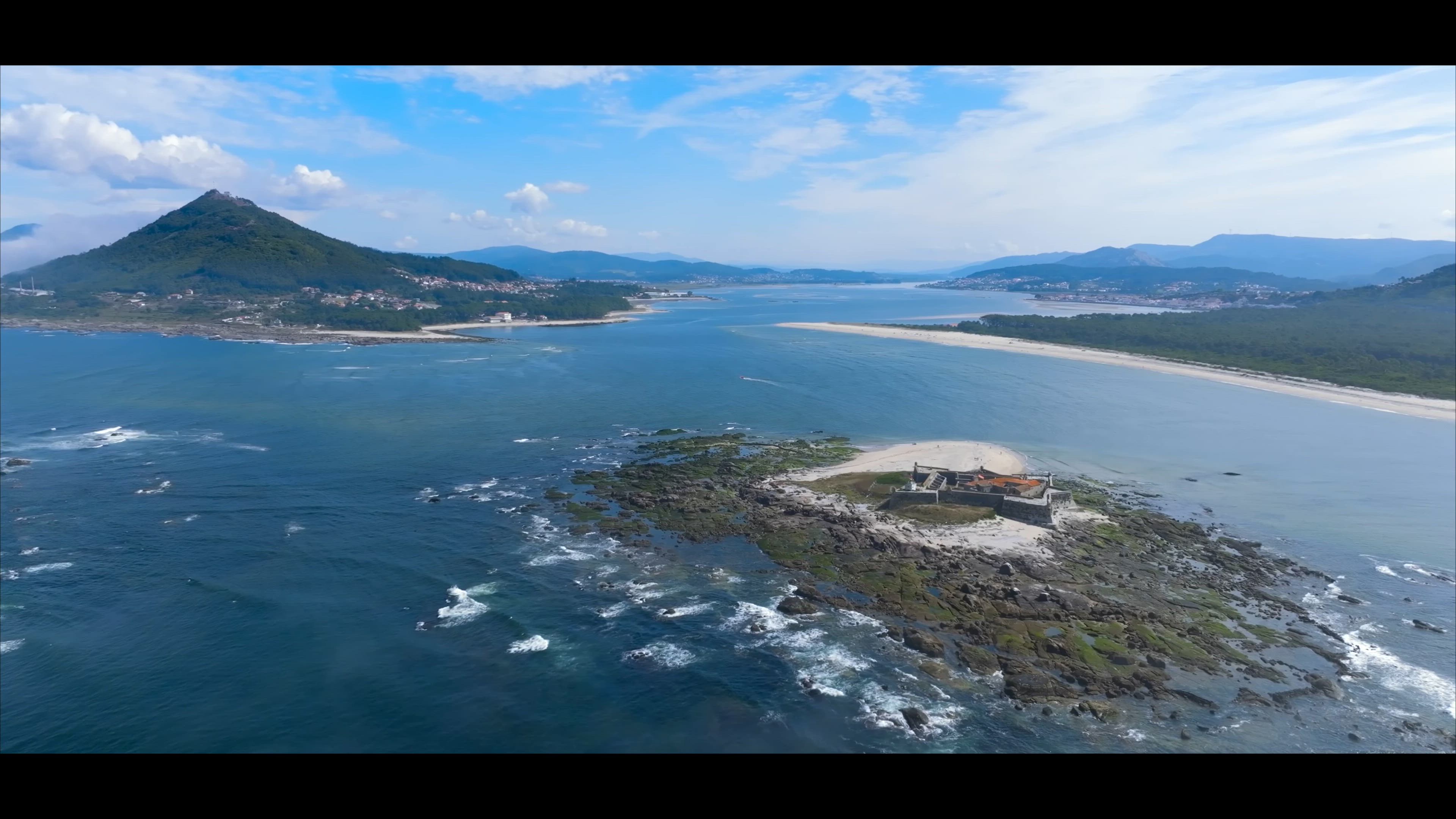
Moledo | Forte da Insua 🇵🇹
AIRVŪZ STAFF NOTE :
In this video by AirVuz contributor Airviewstudio, you'll explore a town on the northern end of Portugal's coastline called Moledo. Part of the municipality of Caminha, it's located just south of the mouth of the Minho River, which is the boundary between Portugal and Spain to the north. The video includes extensive footage of the Ínsua Fort, which lies on a tiny island just offshore. Originally a fortified monastery, the current structure is a bastion fortress which dates to the mid-17th century.
- over 2 years ago
- 233 VŪZ
6 


- 6
- Report
BADGES THIS VIDEO HAS EARNED:

The insua, a granite Portuguese island, with an extension of about 400 meters from north to south, located at the mouth of the Miño River, in the municipality of Caminha, southwest of this town facing the Spanish town of A Guarda. It is at a distance of less than three kilometers from that Miñota city and a kilometer and a half from the Galician Camposancos, but in a straight line it is less than 400 meters from the coast, having been connected on some historical occasions.
In it, a Franciscan community built a monastery in 1392, by determination of John I of Portugal, expanded and improved in 1471. King D. Manuel ordered new remodeling works in 1502, and at the end of that 16th century (under the rule of Philip II of Spain and I of Portugal) works were carried out to place artillery batteries against English and French corsair attacks. But the structure of the beautiful bastioned fort that still remains is from the time of King D. João IV, executed between 1649 and 1652, to protect the entrance to the Miño during the Restoration War. During the French invasions it was occupied by Spanish and French troops.
The Fort has a square shape with two bastions (to the north and west) and two semi-baluarts (to the south and east) at its angles. A ravelin to the northeast defends the entrance door; Together with an exterior wall that covered from north to east, they reinforced the only part of the islet accessible to landing, since the rest of the territory is safeguarded by very compact, irregular and prolonged granite outcroppings. To the southeast there is a triangular projection like a parade ground. On the outer peaks of bastions, semi-baluarts and ravelin, polygonal sentry boxes with hemispherical domes rise.
Up Next
MY YEAR 2023 | PORTUGAL 🇵🇹

- Airviewstudio
- 857 VŪZ
3 - 2
- over 2 years ago
Praia do Forte, Brazil

- imoveisbrasilbahia
- 746 VŪZ
20 - 13
- almost 10 years ago
🌊 Costa da Vela desde el aire 🚁 | Donón, Cabo Home, playas de Melide y Barra (Pontevedra)
- Airviewstudio
- 682 VŪZ
6 - 11
- about 2 months ago
Between legends and nature 🌿 | Ponte de Lima, Labruja and Arcos de Valdevez
- Airviewstudio
- 1.0k VŪZ
8 - 10
- 3 months ago
Viana do Castelo 🇵🇹
- Airviewstudio
- 715 VŪZ
6 - 6
- over 1 year ago
An aerial journey over Monção 🕊️ | Dreamlike landscapes in Portugal
- Airviewstudio
- 688 VŪZ
1 - 0
- 2 months ago
Costa Norte 2 🇵🇹
- Airviewstudio
- 1.2k VŪZ
7 - 7
- over 2 years ago
Mirador de Cotorredondo | Costa da Vela
- Airviewstudio
- 627 VŪZ
4 - 2
- over 2 years ago
Ría de Vigo
- Airviewstudio
- 1.2k VŪZ
7 - 10
- over 1 year ago
Discovering Portugal 🇵🇹 | Guimaraês And Braga | Cinematic Drone 4K
- Airviewstudio
- 799 VŪZ
8 - 4
- over 2 years ago