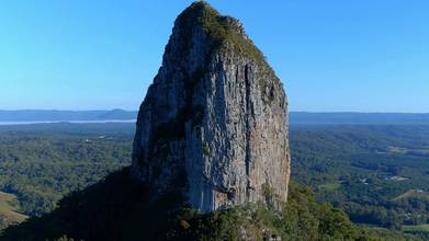
Picturesque Mount Coonowrin, Glasshouse Mountains, Australia
- over 4 years ago
- 329 VŪZ
9 


- 4
- Report
After a colourful sunrise, it was another beautiful morning to fly near Mount Coonowrin in the Glasshouse Mountains. Mount Coonowrin is one of the peaks of the Glass House Mountains, located in Queensland, Australia, 19 km north of Caboolture or about one hour's drive north of the city of Brisbane, Queensland Australia. It is easily distinguished because of its rocky formation at the top. It is also known by its unofficial name Crookneck. The Glass House Mountains are a cluster of thirteen hills that rise abruptly from the coastal plain on the Sunshine Coast, Queensland, Australia. The highest hill is Mount Beerwah at 556 metres above sea level, but the most identifiable of all the hills is Mount Tibrogargan which from certain angles bears a resemblance to a face staring east towards the ocean. The Glass House Mountains are located near Beerburrum State Forest and Steve Irwin Way. From Brisbane, the mountains can be reached by following the Bruce Highway north and taking the Glass House Mountains tourist drive turn-off onto Steve Irwin Way. The trip is about one hour from Brisbane. The Volcanic peaks of the Glass House Mountains rise dramatically from the surrounding Sunshine Coast landscape. They were formed by intrusive plugs, remnants of volcanic activity that occurred 26-27 million years ago. Molten rock filled small vents or intruded as bodies beneath the surface and solidified into land rocks. Millions of years of erosion have removed the surrounding exteriors of volcanic cores and softer sandstone rock. Whilst the traditional names for the hills themselves are very old, the term 'Glasshouse Mountains' was given more recently by explorer Lieutenant James Cook on 17 May 1770. The peaks reminded him of the glass furnaces in his home county of Yorkshire. Matthew Flinders explored the area and climbed Mount Beerburrum after sailing along Pumicestone Passage in 1799. The Glass House Mountains National Landscape was added to the Australian National Heritage List on 3 August 2006. In the land between the peaks, pineapple and poultry farming, as well as commercial forestry and quarrying are the main land uses. The Glass House Mountains are a cluster of thirteen hills that rise abruptly from the coastal plain on the Sunshine Coast, Queensland, Australia. The highest hill is Mount Beerwah at 556 metres above sea level, but the most identifiable of all the hills is Mount Tibrogargan which from certain angles bears a resemblance to a face staring east towards the ocean. The Glass House Mountains are located near Beerburrum State Forest and Steve Irwin Way. From Brisbane, the mountains can be reached by following the Bruce Highway north and taking the Glass House Mountains tourist drive turn-off onto Steve Irwin Way. The trip is about one hour from Brisbane. The Volcanic peaks of the Glass House Mountains rise dramatically from the surrounding Sunshine Coast landscape. They were formed by intrusive plugs, remnants of volcanic activity that occurred 26-27 million years ago. Molten rock filled small vents or intruded as bodies beneath the surface and solidified into land rocks. Millions of years of erosion have removed the surrounding exteriors of volcanic cores and softer sandstone rock. Whilst the traditional names for the hills themselves are very old, the term 'Glasshouse Mountains' was given more recently by explorer Lieutenant James Cook on 17 May 1770. The peaks reminded him of the glass furnaces in his home county of Yorkshire. Matthew Flinders explored the area and climbed Mount Beerburrum after sailing along Pumicestone Passage in 1799. The Glass House Mountains National Landscape was added to the Australian National Heritage List on 3 August 2006. In the land between the peaks, pineapple and poultry farming, as well as commercial forestry and quarrying are the main land uses. Autel Evo 2 Pro – shot in 6K, log, 30fps, and rendered to 4K
Up Next
The Spectacular Glasshouse Mountains - Mavic 3

- Oz Straya Panoramas
- 693 VŪZ
3 - 3
- almost 4 years ago
Cinematic Glasshouse Mountains - full moon & sunrise

- Oz Straya Panoramas
- 1.5k VŪZ
7 - 10
- over 2 years ago
Spectacular Cinematic Montage - Best of South East Queensland, Australia - 4K
- Oz Straya Panoramas
- 818 VŪZ
9 - 6
- over 4 years ago
Best of 2024 - Highlights
- Oz Straya Panoramas
- 992 VŪZ
5 - 4
- 12 months ago
Best of 2023 - Highlights Reel (Southeast Queensland & Tweed Coast, Australia)
- Oz Straya Panoramas
- 1.9k VŪZ
4 - 4
- almost 2 years ago
Picturesque Mount Mitchell, Australia
- Oz Straya Panoramas
- 844 VŪZ
10 - 7
- over 4 years ago
Foggy Brisbane Australia
- Oz Straya Panoramas
- 1.3k VŪZ
3 - 3
- over 1 year ago
Sunrise over a Foggy Brisbane Australia (including Timelapse)
- Oz Straya Panoramas
- 994 VŪZ
6 - 6
- over 1 year ago
Foggy Sunrise Hyperlapse 4K
- Oz Straya Panoramas
- 824 VŪZ
0 - 0
- over 1 year ago
Cinematic Scenic Rim, Australia – Top 10 Region in the World for 2022 (Lonely Planet)
- Oz Straya Panoramas
- 915 VŪZ
4 - 12
- about 4 years ago