Picturesque Mount Mitchell, Australia
AIRVŪZ STAFF NOTE :
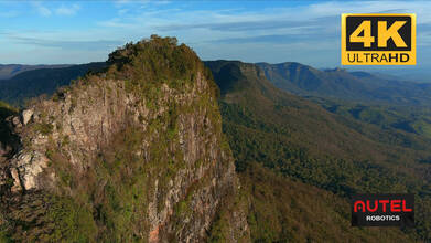
Check out these stunning drone views of Australia's Mt. Mitchell, compliments of AirVuz contributor and pilot Oz Straya Panoramas. The volcanic mountain has dual peaks, the taller of which has an elevation of about 1.17k meters above sea level (a bit over 3.8k ft.). It's part of the Main Range, a forested mountain chain in southeastern Queensland and northeastern New South Wales. Mt. Mitchell is only about an hour's drive west of Brisbane, the Queensland capital and the country's third-largest city.
- about 3 years ago
- 710 VŪZ
11 


- 7
- Report
BADGES THIS VIDEO HAS EARNED:

After an early morning hike to the peak of Mount Mitchell, we were met with a spectacular sunrise & unparalleled 360 degree views. Mount Mitchell (Aboriginal: Cooyinnirra) is a twin-peaked volcanic mountain with an elevation above sea level of 1,168 metres (3,832 ft), located in the Main Range, is about 100 kilometres (62 miles) west of Brisbane, Queensland, Australia and immediately south of Cunninghams Gap. The peak to the south of the gap was named by Allan Cunningham in 1828 and today is part of the Main Range National Park. Cunningham named the mountain after the Surveyor-General, Thomas Mitchell. To the north of Cunninghams Gap is Mount Cordeaux, while Spicers Peak is located a small distance to the south east. A trail, classified as grade 4, traverses 5.1 kilometres (3.2 mi) through woodland, rainforest and montane heath up to the main summit, which offers unparalleled 360 degree views. From the peak on a clear day the tallest buildings in the Brisbane CBD can be seen, as can the D Aguilar Range, Teviot Range, Fassifern Valley and many other parts of the Scenic Rim like Mount Maroon, Mount Lindsay, Mount Barney and Mount Ballow. At the top of mountain you will eventually end up on a knife-edge ridge above sheer cliffs on the East Peak (1175m). Our group were the only people on the mountain on this morning. Shot by the Autel Evo 2 Pro, 4k, Log.
Up Next
Cinematic Scenic Rim, Australia – Top 10 Region in the World for 2022 (Lonely Planet)

- Oz Straya Panoramas
- 902 VŪZ
4 - 12
- over 2 years ago
Spectacular Cinematic Montage - Best of South East Queensland, Australia - 4K
- Oz Straya Panoramas
- 637 VŪZ
9 - 6
- about 3 years ago
The Spectacular Glasshouse Mountains - Mavic 3
- Oz Straya Panoramas
- 604 VŪZ
3 - 3
- over 2 years ago
Best of 2023 - Highlights Reel (Southeast Queensland & Tweed Coast, Australia)

- Oz Straya Panoramas
- 1.7k VŪZ
4 - 4
- 4 months ago
Amazing Twilight Reflections - Australia
- Oz Straya Panoramas
- 1.3k VŪZ
11 - 10
- about 1 year ago
Cinematic Glasshouse Mountains - full moon & sunrise
- Oz Straya Panoramas
- 1.4k VŪZ
7 - 10
- 12 months ago
Cinematic Somerset Dam
- Oz Straya Panoramas
- 779 VŪZ
6 - 12
- 25 days ago
River Lights - Brisbane Australia : DJI Air 3
- Oz Straya Panoramas
- 1.9k VŪZ
8 - 11
- 9 months ago
Cinematic Brisbane - 2032 Olympic City
- Oz Straya Panoramas
- 641 VŪZ
10 - 9
- about 2 years ago
Cinematic Tweed Valley - river to mountains - Autel Lite+
- Oz Straya Panoramas
- 778 VŪZ
10 - 8
- over 1 year ago