Pointe du Hoc, Normandy by drone 4K
AIRVŪZ STAFF NOTE :
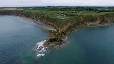
Contributor Marc Olde Kalter created this amazing bird's eye view of one of the most important points in the initial battle for Normandy, France which commenced on D-Day, June 6, 1944. Pointe Du Hoc has commanding views of what became Omaha and Utah Beaches, the two landing zones assigned to the USA's forces. On Day 1 of the invasion, US Army Rangers captured Point Du Hoc and fought off German counter-attacks, securing the beaches from flanking fire which could have derailed the entire operation.
- almost 10 years ago
- 1.1k VŪZ
14 


- 11
- Report
BADGES THIS VIDEO HAS EARNED:

Pointe du Hoc is a promontory with a 100 ft (30 m) cliff overlooking the English Channel on the coast of Normandy in northern France. During World War II it was the highest point between Utah Beach to the west and Omaha Beach to the east. The German army fortified the area with concrete casements and gun pits. On D-Day (6 June 1944) the United States Army Ranger Assault Group assaulted and captured Pointe du Hoc after scaling the cliffs.
Up Next
Norway from the air (short version, 2015)

- Miko
- 1.0k VŪZ
17 - 11
- almost 10 years ago
Normandie and Bretagne drone video
- XG121
- 885 VŪZ
2 - 2
- almost 5 years ago
Norway from the air (Long version) summer 2015
- Miko
- 641 VŪZ
13 - 5
- almost 10 years ago

phare de la vieille

- capitaine citron
- 751 VŪZ
9 - 9
- over 8 years ago
Golfe du Morbihan (Brittany) - 4K

- Mattcoq
- 1.0k VŪZ
14 - 9
- almost 8 years ago
Bretagne | Pointe du Raz, Cap Sizun 2023 Contes et légendes

- Ageff Prod Marc Ge...
- 2.1k VŪZ
4 - 7
- about 3 years ago
Dangerous Cliff Fishing in Sagres, Portugal - Cabo de Sao Vincente

- Marc Olde Kalter
- 1.1k VŪZ
11 - 12
- over 8 years ago
North Coast of Bretagne (🇫🇷France) from above

- XL Creations
- 1.6k VŪZ
1 - 1
- almost 5 years ago
De Loctudy à la Pointe du Raz - Finistère (Bretagne)

- Lumy
- 602 VŪZ
14 - 10
- over 6 years ago