Interested In This Footage?
Surselva - Imboden Region (Grisons, Switzerland)
- over 3 years ago
- 134 VŪZ
6 


- 6
- Report

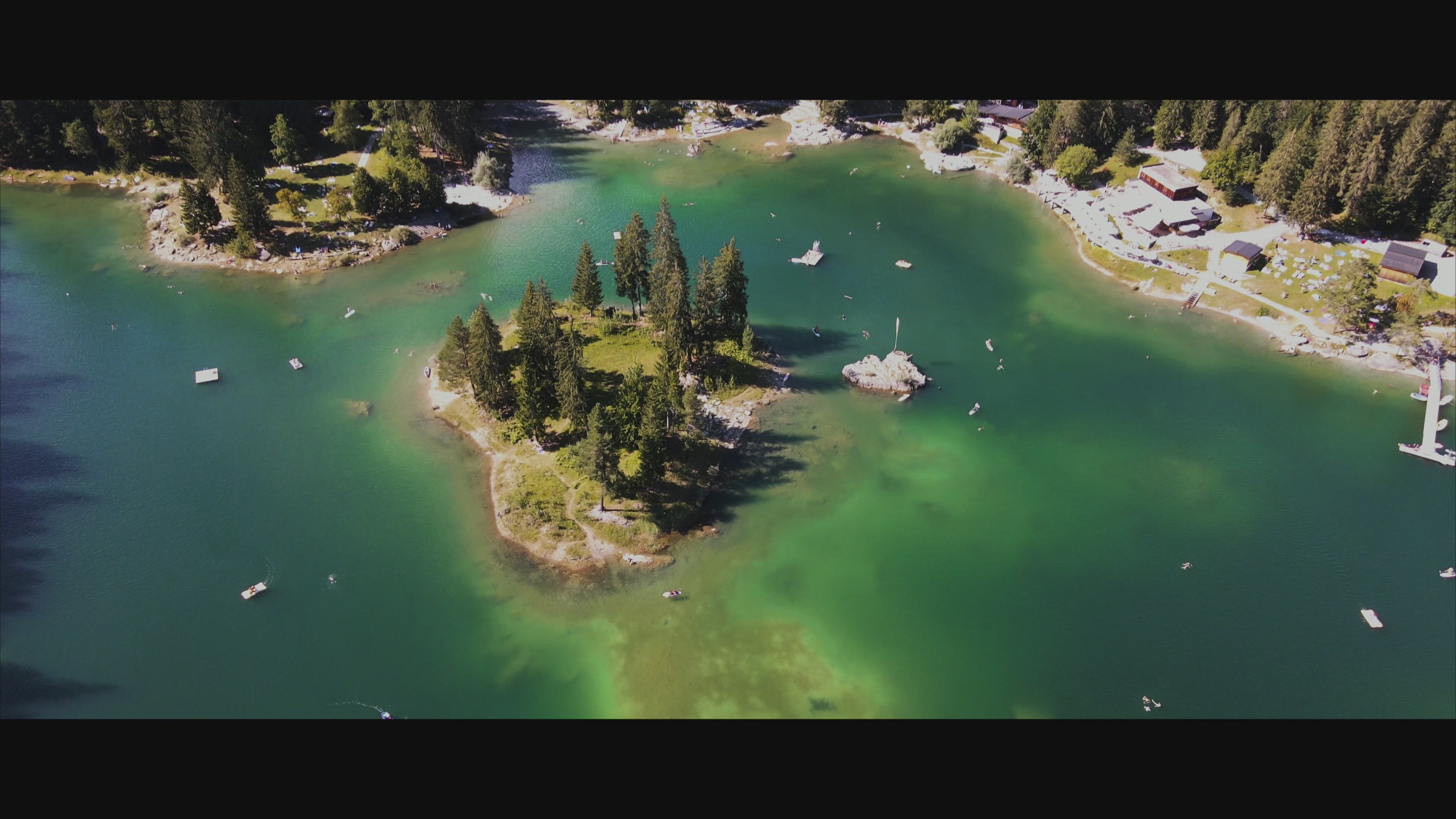
The Vorab Glacier is a 2 km long glacier situated in the Glarus Alps in the cantons of Glarus and Grisons. It lies on the east side of the Vorab, between 2,600 and 3,000 metres above sea level. In 1973 it had an area of 2.17 km². Swiss Tectonic Arena Sardona The collision of Africa and Europe resulted over millions of years in the formation of the Alps. Gargantuan forces propelled rock layers over one another, folding and splitting them. At the Tectonic Arena Sardona, shared between the Canton of Glarus, St. Gall and Graubünden, you can see the result of these processes clearly. The region offers dramatic insights into how mountains are formed. Natural Heritage since 2008. Just beneath the ridge of the Tschingelhörner, at an altitude of 2,600 metres, the famous Martinsloch opens up. This strange, almost triangular opening, with a diameter of around 18 metres, was formed by the accelerated erosion of a more fragile part of the rock. It is very special since it is a kind of natural calendar. Twice a year, roughly a week before the spring equinox and a week after the autumn equinox, the rising sun shines through the hole and lights up the church tower of the village of Elm, for about 2 minutes. Then it disappears behind the wall of rock before emerging above the ridge some 15 minutes later. This occurrence has fascinated people for centuries. The other mysterious characteristic of the Tschingelhörner and of the surrounding peaks is a grey-yellowish line, wedged between two layers of Alpine rock. This distinct line has intrigues the scientific world for a long time and prompted a considerable number of arguments amongst geologists, since it overturned, in the literal sense of the word, the prevailing theories regarding the development of the Earth’s crust. This “magic line”, as it is often called, ultimately provided a key to our understanding of the tectonic processes that gave rise to the Alps and to other similar mountain ranges. Crestasee is a small lake shared by the municipalities of Flims and Trin in the Grisons, Switzerland. From 1892 a guest house on its northern end served as pension and still is a restaurant today in its original state. There is no tributary to the lake and whilst walking along its shores you may be surprised by finding the lake both sides of you, realizing, that the holes between the rocks lying around the lake are filled with water. The rough character of the whole area derives from being a debris area of the gigantic Flims Rockslide, where waters flow underground until feeding lakes at certain spots such as Crestasee, Caumasee or Lag Prau Pulté. Less than 100 yards (91 m) from its northern end a gorge called "Felsbachschlucht" is formed by river Flem, coming from Flims, whose Romansh name is Flem anyway. The waters from the lake and river are independent, and of course the river had only some 10 000 years to create the gorge as this is the age of the rockslide. Caumasee is a lake near Flims, in the Grisons, Switzerland. It is one of the lakes on the Flims Rockslide deposits. The lake is fed from underground sources. Its surface area is 10.3194 ha. The level of the lake varies by approximately 4 to 5 meters along with the varying underground water flow during the year, hence reaches its minimum by the end of April when snow melting in the mountains increases. A maximum level is reached by mid July but may be topped in August even after previous falling due to summer rain. The very western bay never freezes in winter, probably showing a maximum water flow in this area. When the lake is at a low level, with a small volume of water, it warms up sooner than most lakes in the region, so people can be seen starting to swim the lake in April while bigger lakes even in lower areas of Switzerland remain rather cool. Water temperature in summer is at an average 21 Celsius, with a maximum around 24 Celsius. The lake is in a huge forest that was allowed to remain on the agriculturally useless debris area of the biggest prehistoric rockslide in the Alps and can only be reached by a footpath (wheelchair accessible), possibly using a funicular built in 1939, refurbished in 1988 on its original tracks (running May to October only). The walk from the edge of town to the funicular takes about 10 minutes. Ruinaulta - Switzerland's Grand Canyon The Rhaeto-Romanic speaking inhabitants of the Vorderrhein ravine call it Ruinaulta, a word meaning high heap of rubble. And indeed, the bizarre whitish rock formations consist of debris from a prehistoric rockslide that blocked the Rhine near Flims after the retreat of the Ice Age valley glacier. Since then the river has eaten its way through the rubble, forming an impressive gorge. The Rhaetian Railway runs through the canyon, where adventurers enjoy river rafting and observers make their way to the “il Spir” viewing platform. What has come into being is a natural, magical place full of mysterious lakes in the Mountain Forest, rare orchids and breeding grounds for endangered species of birds. Further below, gently sloping sand banks alternate with wild rapids and make the region of the Rhine gorge an adventure for hikers, bikers, rafters, canoers, nature lovers and explorers alike. Gletschermühlen The glacial mills on Alp Mora are among the most beautiful and extraordinary natural formations in Flims Laax Falera. The Maliensbach stream, which originates on the Alp Mora in Trin, formed large basins here over the course of centuries. Today the basins stand in line like a string of pearls. The roughly 20 glacial mills are filled with crystal-clear, turquoise-coloured water once the snow has melted, presenting the perfect place to bathe during summer months. Lined up in a row, with views of the Safien valley, the glacial mills offer a spectacular photo opportunity. Bargis mountain valley - Paradise for mountaineers Are you a true mountain lover who prefers to get away from the crowds? Then you’ve come to the right place in Bargis. The mountain valley is a renowned as a paradise for mountaineers and is the perfect base for short walks or long mountain treks to Flims or Trins. Bargis is hidden behind a rock face created by the Flims landslide at an altitude of 1,550 metres. As the access road is blocked for private traffic, this is the perfect place to enjoy the peace and tranquillity of the mountains.
Up Next
Lukmanier Pass (Grisons/Ticino, Switzerland)

- Kpax
- 764 VŪZ
11 - 12
- over 3 years ago
Lai Blau (Grisons, Switzerland)
- Kpax
- 1.2k VŪZ
8 - 11
- 4 months ago
Splügen Tambo - Snowboarding (Grisons, Switzerland)
- Kpax
- 1.1k VŪZ
5 - 8
- about 2 years ago
Cama Lake 🍁 (Grisons, Switzerland)
- Kpax
- 5.8k VŪZ
14 - 20
- over 3 years ago
Julierpass - Spring Edition 🌸 (Grisons, Switzerland)
- Kpax
- 1.3k VŪZ
4 - 3
- about 2 years ago
Cama Lake - Summer Edition 🌞 (Grisons, Switzerland)
- Kpax
- 1.7k VŪZ
8 - 14
- 10 months ago
Lai da Rims v2.0 (Grisons, Switzerland)
- Kpax
- 902 VŪZ
8 - 12
- 8 months ago
San Bernardino - Winter Edition ❄️ (Grisons, Switzerland)
- Kpax
- 790 VŪZ
11 - 12
- over 3 years ago
Pizzo Uccello - Peak of the Bird (Grisons, Switzerland)
- Kpax
- 772 VŪZ
9 - 8
- over 1 year ago
Landwasser Viaduct (Grisons, Switzerland)
- Kpax
- 1.2k VŪZ
9 - 14
- over 3 years ago