follow me
- almost 7 years ago
- 141 VŪZ
3 


- 1
- Report
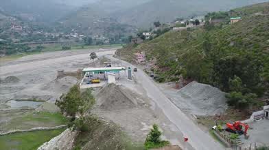
District Lower Dir is located in the north-western part of Khyber Pakhtunkhwa province and is spread over an area of 1583 square kilometers. Most of the state layed in the valley of the Panjkora river, which originates in the Hindu Kush mountains and joins the Swat River near Chakdara. Apart from small areas in the south-west, Dir is a rugged, mountainous zone with peaks rising to 5,000 metres (16,000 ft) in the north-east and to 3,000 metres (9,800 ft) along the watersheds, with Swat to the east and Afghanistan and Chitral to the west and north.
The topography of the district is dominated by the mountains and hills which are part of the ranges/branches of southern Hindukush with the highest peaks in the northern part of Dir. The major valleys of Lower Dir include; Timergara, Jandool Maidan, Samarbagh, and Asban.
Up Next
Fishing Hut in Chakdara

- majidafridi2003
- 1.3k VŪZ
15 - 16
- over 4 years ago
offroad adventure
- majidafridi2003
- 1.3k VŪZ
17 - 13
- almost 7 years ago
gomal zam dam
- majidafridi2003
- 659 VŪZ
12 - 8
- over 6 years ago
Gomal Zam Dam
- majidafridi2003
- 5.1k VŪZ
15 - 11
- over 6 years ago
The Amazing Thailand with The Sanctuary of Truth Castle

- 2wheels1drone
- 516 VŪZ
9 - 11
- about 8 years ago
Veterans Day Family time

- LandWaterXplore
- 839 VŪZ
2 - 2
- over 8 years ago
San Diego by Drone
- LandWaterXplore
- 612 VŪZ
6 - 1
- over 8 years ago
Drone Surfing Oceanside
- LandWaterXplore
- 1.1k VŪZ
9 - 3
- over 8 years ago
THIS IS SLOVAKIA

- David.Haring
- 1.5k VŪZ
35 - 18
- over 5 years ago
THE STORY OF MY YEAR 2017 | ZILVER SCHMITZ

- ZilverSchmitz
- 6.5k VŪZ
43 - 34
- over 6 years ago