Interested In This Footage?
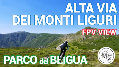
Alta Via dei Monti Liguri, Parco del Beigua | FPV drone exploring Faiallo pass overlooking Genoa sea
- almost 2 years ago
- 1.1k VŪZ
8 


- 14
- Report
Alta Via dei Monti Liguri, Beigua Park | FPV view of Genoa sea from the Faiallo stop The Alta Via of Monti Liguri is a trekking trail 440km long, with 44 stages that extends all along the Liguria. We explored the part of the trail that crosses with the Beigua Regional Natural Park with our drones fleet. The trail can be done by foot, on horseback or even by bike, there are so much options! The Alta Via is also part of a bigger trail, the Sentiero Italia (6000km long!) that also pass by Trieste, Aosta Valley, Sardinia, Apennine Mountains… just to name a few. The landscapes here are wild, full of rocky peaks overlooking the sea and wide field dotted with colorful flowers, overflown by various birds of prey. From the wintry golden hills to the bright green summery expanses this leg of the Alta Via dei Monti Liguri can really give amazing and unforgettable views!
Build used: Pablo Long Range 7 inch: https://rotorbuilds.com/build/26957 DJI Mavic 3 📷 Shot with GoPro Hero10 ✨ Check out our website! https://www.fpvflow.it ✨ 🚀 Follow us on Instagram for more FPV content! DM us for business inquiries! 💪 FPVFlow: @fpvflow https://www.instagram.com/fpvflow/ FPV Pilot: @alessandrobava https://www.instagram.com/alessandrob... FPV Pilot: @veronique_fpv https://www.instagram.com/veronique_fpv/ FPVFlow Crew member & Pilot in the making: @xanderfpv9 https://www.instagram.com/xanderfpv9/ Fixed camera operator: @marcofarmalli https://www.instagram.com/marcofarmalli
Up Next
Snowkite Event @ Passo Del Tonale - Italy | FPV drone view

- FPVFlow
- 1.0k VŪZ
6 - 5
- 2 months ago
Cascata delle Marmore | FPV drone diving one of the highest artificial waterfalls in Europe
- FPVFlow
- 1.4k VŪZ
7 - 6
- almost 2 years ago
First ridiculous chase attempt

- WillyWonka
- 637 VŪZ
4 - 8
- over 1 year ago
Surfing Sardinia in FPV | A journey through the mixed beautiful views of the island
- FPVFlow
- 1.2k VŪZ
9 - 8
- over 1 year ago
Castello di Proh

- Viky Dog
- 1.3k VŪZ
16 - 18
- over 4 years ago
Portofino, GoPro Million Dollar Challenge MDC21 WINNER | FPV views of the Dolce Vita
- FPVFlow
- 1.7k VŪZ
12 - 16
- over 2 years ago
Wind farm discovery in Liguria | FPV drone cinematic Italy
- FPVFlow
- 506 VŪZ
4 - 2
- about 2 years ago
Carsulae, Ruins of a Roman city - Umbria, Italia | FPV Drone Explores Parco Archeologico di Carsulae
- FPVFlow
- 1.5k VŪZ
5 - 6
- over 1 year ago
Virtual Tour Grand Hotel Mont Blanc 5* Courmayeur

- L. Morandini
- 810 VŪZ
14 - 11
- about 3 years ago
Poppi and Cilento National Park, Salerno

- franxifra
- 3.1k VŪZ
28 - 16
- almost 7 years ago