Interested In This Footage?
Durmitor // Montenegro 2023
AIRVŪZ STAFF NOTE :
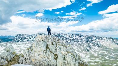
AirVuz contributor Nikola Zindovic brings us this excellent drone video from the Durmitor Mountains in the small Balkan country of Montenegro. Part of the Dinaric Alps, a mountain system which runs down the western side of the Balkan Peninsula, the Durmitor Mountains are located in the northern part of the roughly diamond-shaped country. Thei highest peak (Bobotov kuk) has a summit elevation of about 8.3k ft. above sea level or around 2.5k m. The video was filmed with a DJI Mavic 3 Cine drone.
- almost 2 years ago
- 1.8k VŪZ
13 


- 15
- Report
BADGES THIS VIDEO HAS EARNED:

Durmitor National Park includes the Durmitor mountain massif, the canyons of the Tara, Draga, Sušice rivers and the highest part of the Komarnica canyon valley, from which numerous mountain peaks rise, 48 of which are over 2,000 meters above sea level. The highest peak is Bobotov kuk, 2,525 m above sea level. The surface of the Park is 34,500 ha, and the territory belongs to the following municipalities: Žabljak, Šavnik, Plužine, Pljevlja and Mojkovac. The climate is temperate-continental, sub-mountain and mountain. It is characterized by long and cold winters and relatively short and cool summers. The transitional period between seasons is less pronounced, and autumns are slightly warmer than spring.
Up Next
Montenegro // Mountains Durmitor // 2023

- Nikola Zindovic
- 1.6k VŪZ
11 - 16
- about 2 years ago
Bjelasica (Bjelogrivac) Montenegro 2023
- Nikola Zindovic
- 1.5k VŪZ
8 - 9
- about 2 years ago
Mojkovac Start Spring 2023
- Nikola Zindovic
- 1.4k VŪZ
9 - 5
- about 2 years ago
River Tara and Dobrilovina // Montenegro // May 2023
- Nikola Zindovic
- 1.6k VŪZ
6 - 7
- about 2 years ago
Durmitor // Stozina 1908mnv // 2023
- Nikola Zindovic
- 1.6k VŪZ
4 - 3
- almost 2 years ago
Sveti Stefan // Budva // Montenegro 2023
- Nikola Zindovic
- 640 VŪZ
4 - 3
- about 2 years ago
Montenegro Meanders of Cehotine // Montenegro 2023
- Nikola Zindovic
- 956 VŪZ
2 - 1
- almost 2 years ago
Durmitor-Prutas 2393mnv and game of chamois and lonely roe deer 2023
- Nikola Zindovic
- 817 VŪZ
4 - 3
- almost 2 years ago
River Tara and Rafting // Montenegro // 2023
- Nikola Zindovic
- 1.4k VŪZ
8 - 10
- almost 2 years ago
Durmitor National Park - Montenegro. Drone film - cinematic DJI Mini 3 PRO + FPV
- sinaysky
- 2.0k VŪZ
7 - 8
- over 2 years ago