Dún Lúiche In 4K | Donegal, Ireland | Cinematic, Mavic Air 2
AIRVŪZ STAFF NOTE :
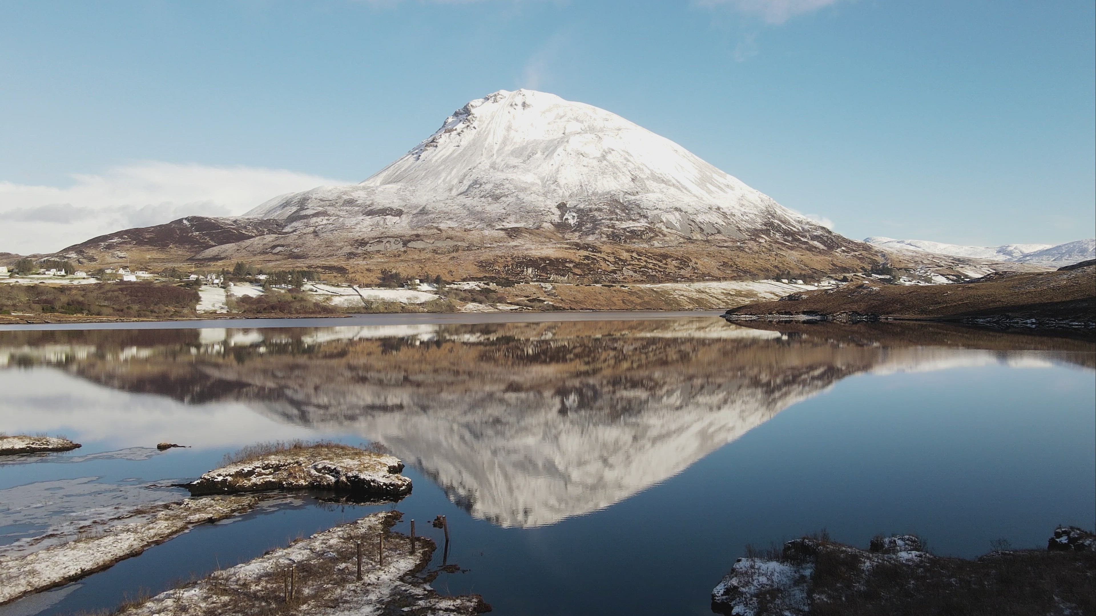
For a first upload to AirVuz, brand-new contributor Kevin McBride brings us this stunning drone video of an Irish village called Dunlewey or Dún Lúiche. It's located on the shores of its namesake lake at the foot of Mt. Errigal in County Donegal, the northernmost county of the Republic of Ireland. Part of a region known as Gweedore which is considered one of the cradles of Irish culture, Dunlewey's Gaelic name translates to "fort of Lugh", an ancient Irish god. The video was filmed with a DJI Mavic Air 2 drone.
- over 4 years ago
- 1.3k VŪZ
16 


- 28
- Report
BADGES THIS VIDEO HAS EARNED:

Dunlewy, officially known by its Irish name Dún Lúiche, is a small Gaeltacht village in the Gweedore area of County Donegal, Ireland. It sits in the Poisoned Glen, at the foot of Mount Errigal 751-metre (2,464 ft) the tallest peak in County Donegal, and the 76th tallest peak in Ireland. Errigal was voted 'Ireland's Most Iconic Mountain' by Walking & Hiking Ireland in 2009. on the shore of Dunlewey Lough. It has a tourist center, called the Lakeside Centre or Ionad Cois Locha, which offers boat trips of the lake. To the west of the lake is a ruined church. The name Dún Lúiche means "fort of Lugh", an ancient Irish god. Near the Lakeside Centre is a modern wooden sculpture of the god. Folklore says that the Poisoned Glen is where Lugh slayed Balor, and that it is so named because poison seeped from Balor's 'evil eye
Up Next
St Patrick's Purgatory, Lough Derg, Ireland. Cinematic 4K Drone Footage.

- Mark's Mavic 2
- 729 VŪZ
12 - 9
- over 4 years ago
Fly Over Donegal, Ireland. Glenveagh National Park, Doe Castle, Mount Errigal, Dunlewey Church. 4K.
- Mark's Mavic 2
- 699 VŪZ
14 - 11
- over 4 years ago
Ireland 🇮🇪 County Donegal. 4k Drone Film

- Nathan Jermy
- 1.7k VŪZ
44 - 31
- over 7 years ago
IRELAND - Donegal Revisited II

- Nathan Jermy
- 1.3k VŪZ
18 - 17
- about 6 years ago
Ireland By Drone

- AirVūz Social
- 1.4k VŪZ
10 - 8
- about 4 years ago
Fanad Lighthouse: Donegal, Ireland

- hallmark7
- 1.4k VŪZ
10 - 17
- about 6 years ago
Diving off the Second-Highest Sea Cliff in Ireland

- Ton18Drone
- 716 VŪZ
8 - 12
- 3 months ago
Fanad Lighthouse During Twilight
- Martin McKenna
- 1.0k VŪZ
15 - 15
- over 5 years ago
Crohy Head Co.Donegal - Ireland
- Ton18Drone
- 788 VŪZ
5 - 9
- 3 months ago
Film Reel 2019

- eireialcreations.ie
- 1.0k VŪZ
14 - 14
- almost 5 years ago