Florida Keys from Islamorada to Seven Mile Bridge
AIRVŪZ STAFF NOTE :
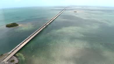
Contributor and pilot TampaRandy created this drone tour of a stretch of the Florida Keys running from Islamorada and Seven Mile Bridge. While it's not actually seven miles (it's 10.9k meters or about 6.8k miles), it was one of the longest bridges in the world when it opened in 1912 as a railway extension. The popular drive is actually two bridges now; the more recent one was built in 1982. The bridge was the filming scene in the 18th James Bond film License to Kill (1989) in which a truck is driven off of it.
- over 8 years ago
- 2.0k VŪZ
16 

- 8
- Report
BADGES THIS VIDEO HAS EARNED:

Aerial of the Florida Keys featuring the Overseas Highway and the Seven Mile Bridge. We follow the Highway 1 with aerial footage from Islamorada to Marathon Florida. The original roadway from the Mainland to Key West opened in 1928 as State Road 4A, however there was a 41 mile gap from Lower Matecumbe and No Name Keys. When the Labor Day Hurricane of 1935 destroyed parts fo the Overseas Railroad, the bridges where retrofitted with concrete for vehicular traffice. In 1938 the highway opened as Route 1 and finally connected Key West with the Mainland.
The Seven Mile bridge is actually 6.79 miles and opened in 1982. The old bridge is now used for pedestrian and bicyclist traffic. In 2014 the Florida Department of Transportation approved a $77 Million plan to restore the old bridge.
We used the new X-Star Premium drone for this. We have done reviews on the picture quality which is much better than the Phantom youtube.com/watch?v=FNnX5HFlmFs . but this video was impressed with how it dealt with wind. At times we had very strong gusts of wind, probably about 25mph, and it the drone still remained very steady, and even against the wind was still able to maintain about 7-10mph.
For more on our Aerial Photography see celebrationsoftampabay.com/aerial-photographers-tampa/ or contact Randy@CelebrationsofTampaBay.com
Up Next
Islamorada // Florida Keys
- Tamas_Supertramp
- 505 VŪZ
7 - 9
- over 6 years ago
New ! DJI Phantom 4 - Sunset @ Florida's Keys (4K)
- Planet Phantom
- 668 VŪZ
6 - 11
- over 7 years ago
4K Trip Video Florida Keys DJI Mavic Air

- ablazquezinesta
- 1.6k VŪZ
22 - 17
- almost 7 years ago
Explore the Florida Keys by Air

- NonexistentJay
- 2.4k VŪZ
40 - 26
- about 7 years ago
Florida Keys
- shkundas
- 967 VŪZ
17 - 21
- over 5 years ago
Vicksburg Mississippi I-20 River Bridge
- TampaRandy
- 2.6k VŪZ
15 - 6
- over 8 years ago
Drone selfie in Bahia Honda (Florida)

- AurelBaud
- 1.2k VŪZ
25 - 13
- almost 9 years ago
Florida Keys Aerial Footage 4K
- ablazquezinesta
- 1.9k VŪZ
26 - 14
- almost 7 years ago
Fort Lauderdale, the City of Yachts
- TampaRandy
- 609 VŪZ
19 - 11
- almost 9 years ago
Florida Keys

- Adrian Lowe
- 1.0k VŪZ
11 - 10
- over 2 years ago