Interested In This Footage?
The Rheinwaldhorn - Adula (Ticino, Switzerland)
AIRVŪZ STAFF NOTE :
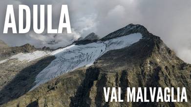
Top contributor Kpax brings us this stunning drone video from one of the tallest mountain in Italian-speaking Switzerland. It's called the Rheinwaldhorn, and it lies on the border between the cantons of Ticino and Grisons. With a peak altitude of just under 11.2k ft. above sea level (about 3.4k m), it's the tallest mountain in the canton of Ticino. The mountain is also known by the names Rheinwaldhorn, Adula and Piz Valrhein. While the summit of the mountain was first scaled in 1789, it was not reached again for another 70 years.
- over 1 year ago
- 1.7k VŪZ
12 


- 22
- Report
BADGES THIS VIDEO HAS EARNED:

The Rheinwaldhorn (Italian: Adula) is the highest point in the Swiss canton of Ticino at 3,402 metres above sea level. It lies on the border between the cantons of Graubünden and Ticino, in the Adula massif, part of the St. Gotthard massif of the Lepontine Alps in southern Switzerland.
The mountain is known under different names, Rheinwaldhorn, Adula or Piz Valrhein.The group of the snowy peaks lying between the two principal branches of the Rhine were known in the Middle Ages by the names Mons Aquila or Mons Avium. From the Romansh form of the first comes the name Adula, which is used to designate the north-eastern portion of the Lepontine Alps.The German name "Rheinwaldhorn" comes from the Rheinwald region.
Up Next
Larescia Peak - “Eagle’s Nest” Bivouac (Ticino, Switzerland)

- Kpax
- 1.1k VŪZ
7 - 12
- about 2 years ago
Carassina Valley 🍁 (Ticino, Switzerland)
- Kpax
- 1.0k VŪZ
12 - 20
- over 3 years ago
Pizzo Rossetto - Winter Edition ❄️ (Ticino, Switzerland)
- Kpax
- 543 VŪZ
4 - 5
- 3 months ago
Val Malvaglia (Ticino, Switzerland)
- Kpax
- 883 VŪZ
8 - 14
- almost 4 years ago
Lake Chironico (Ticino, Switzerland)
- Kpax
- 1.9k VŪZ
7 - 10
- 5 months ago
Chüebodengletscher - Summer Edition (Valais, Switzerland)
- Kpax
- 1.6k VŪZ
2 - 4
- over 2 years ago
Lake Pozzöi - Autumn Edition 🍁(Ticino, Switzerland)
- Kpax
- 918 VŪZ
6 - 8
- over 2 years ago
Piatto della Froda (Ticino, Switzerland)
- Kpax
- 1.0k VŪZ
15 - 22
- over 4 years ago
Lago della Sella - Cima Posmeda - Passo Scimfuss (Ticino, Switzerland)
- Kpax
- 1.3k VŪZ
18 - 21
- over 4 years ago
Monte Lema - 🍁 Autumn / Winter ❄️ (Ticino, Switzerland)
- Kpax
- 847 VŪZ
6 - 8
- over 1 year ago