Winnipeg's Red River Floodway in Action
- about 8 years ago
- 225 VŪZ
10 


- 6
- Report

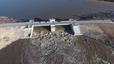
Aerial drone footage of the Red River Floodway in action just south of Winnipeg, Manitoba, CANADA, April, 2017.
The Floodway was built between 1962 and 1968 and was first used in spring, 1969. It is a 47 km (29 mi) long channel which, during flood periods, and controlled by floodgates, takes part of the Red River's flow around the city of Winnipeg, Manitoba to the east and discharges it back into the Red River below the dam at Lockport, Manitoba. It can carry floodwater at a rate of up to 4,000 cubic metres (140,000 cubic feet) per second, expanded in the 2000s from its original channel capacity of 1,700 cubic metres (60,000 cubic feet). It was built partly in response to the disastrous 1950 Red River flood.
For further information, visit: http://www.gov.mb.ca/flooding/fighting/floodway.html
Music:
Peyruis – Escape
FreeBackgroundMusic
Website - www.freebackgroundmusic.co.uk
YouTube - www.youtube.com/freebackgroundmusics
SoundCloud - @freebmusic
Facebook - www.facebook.com/FreeBackgroundMusics
Twitter - twitter.com/FreeBMusic
Google+ - goo.gl/TybZuK
Peyruis - Escape
► SoundCloud - @peyruis
► Facebook - www.facebook.com/Peyruis-738726422884978/
► YouTube - www.youtube.com/channel/UCJ-LrG53mS4WTfL_fmSAhqA
https://soundcloud.com/freebmusic/peyruis-escape-freebackgroundmusic
Up Next
FPV WATER GAMES
- Red—fpv
- 2.5k VŪZ
35 - 15
- almost 7 years ago
ZAPATA FLYRIDE/FLYBOARD
- Red—fpv
- 1.2k VŪZ
24 - 8
- almost 7 years ago
Ice Fishing on Lake Winnipeg, Manitoba (4K)

- Dronerdahl
- 2.0k VŪZ
17 - 16
- about 8 years ago
WAKEBOARD WITH PRO RIDER DANIEL GRAND / YANNICK PATON CASTANO
- Red—fpv
- 1.4k VŪZ
23 - 10
- almost 7 years ago
WAKEBOARD FPV DRONE PROXIMITY EPIC FLIGHT
- Red—fpv
- 1.2k VŪZ
23 - 9
- over 8 years ago
Twin Cities River Rats Waterski Team

- Matt Rafferty
- 1.4k VŪZ
17 - 13
- over 8 years ago
TOW IN SUR WATER SPORT WITH DRONE FPVPURSUITE
- Red—fpv
- 838 VŪZ
20 - 11
- over 7 years ago
Droning a Sewage Treatment Plant Construction Site
- Dronerdahl
- 7.1k VŪZ
11 - 2
- almost 8 years ago
Saint Boniface Cathedral - Winnipeg, MB

- Blaze
- 1.1k VŪZ
23 - 4
- almost 8 years ago
Flyboard show Daniel Guerra world champion 2018
- Red—fpv
- 1.1k VŪZ
21 - 10
- over 6 years ago