Interested In This Footage?
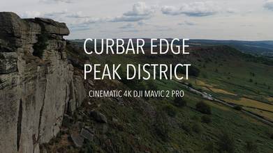
Curbar Edge, Peak District Derbyshire UK
AIRVŪZ STAFF NOTE :
Curbar Edge is a name which is well-known to rock climbers around the world. It's a gritstone escarpment in the UK's Peak District National Park in Derbyshire, one of the counties of the English Midlands. In this excellent drone video by AirVuz contributor Dr0neWerks, you'll get an aerial view of this natural wonder, which is located near the villages of Baslow, Calver, and Froggatt. Curbar Edge features prominently in the modern history of rock climbing, which is believed to have originated in the Peak District in the early 1900's.
- over 2 years ago
- 606 VŪZ
10 


- 8
- Report

BADGES THIS VIDEO HAS EARNED:

Curbar Edge is a gritstone moorland escarpment above the village of Curbar, in Derbyshire, England and close to the villages of Baslow, Calver, and Froggatt. It is located within the Peak District National Park at an altitude of 958 ft (292 m).[1] It is regarded as a significant location for rock climbing, both regionally and nationally, in terms of both the historical development of the sport and as the location of first ascents
Curbar Edge is located in the Dark Peak, the area of the Peak District characterized by peat moorland and gritstone rock.[3] The Edge is one of a long series of west-facing gritstone escarpments, collectively known as the Eastern Grit.[4] A short walk away from Curbar Edge is White Edge, which is visible east of the location.[5] The ground is uneven due to the presence of the Big Moor.[6] In the same area of Curbar Edge is located Padly Gorge, on the A6187, close to Grindleford village,[7] this area is recognised as a Site of Special Scientific Interest (SSSI).[8] Another place of interest located near Curbar Edge is Linacre Reservoirs, built between 1855 and 1904, located in Chesterfield, Derbyshire.[9]
Curbar Edge is situated between Sheffield and Manchester.[10] Curbar Edge is located in the same area of smaller settlements as Chesterfield, 8 miles (13 km), Dronfield 8 miles (13 km), Matlock 13 miles (21 km), Staveley 12.4 miles (20.0 km) and Buxton 16 miles (26 km).[11]
The average elevation of the Edge is 849.7 ft (259.0 m), the maximum elevation is 1,276 ft (389 m) and the minimum elevation is 387 ft (118 m).
Up Next
Winter at Winnats Pass in the Peak District UK

- Dr0neWerks
- 648 VŪZ
5 - 5
- about 2 years ago
Stanage Edge, Peak Districk - Drone Footage #parrotanafi

- hittheroadlat
- 571 VŪZ
14 - 10
- over 5 years ago
Our 2022 Show Reel, Please Have a Watch and Enjoy the Clips from this Years Flights
- Dr0neWerks
- 662 VŪZ
4 - 3
- over 2 years ago
THE PEAK DISTRICT | FPV

- Rob Bates Photogra...
- 1.1k VŪZ
9 - 12
- almost 3 years ago
Ladybower and Bamford Edgeearly morning drone footage with beautiful light

- TingTong John
- 668 VŪZ
10 - 11
- over 4 years ago
ALPORT CASTLES | PEAK DISTRICT Cinematic FPV
- Surge FPV
- 567 VŪZ
3 - 1
- almost 3 years ago
Winnats Pass // Aerial Adventure // Episode 9 // Peak District // Drone DJI Phantom 4 Pro

- Joshua Paul Gardner
- 959 VŪZ
18 - 13
- over 6 years ago
Stanage Edge walk in the afternoon with my drone
- TingTong John
- 856 VŪZ
10 - 10
- over 4 years ago
Peak District National Park, United Kingdom

- Vaidasr7
- 1.1k VŪZ
9 - 12
- almost 5 years ago
England's Peak District: Phantom 4 Pro
- nevinxavier
- 1.3k VŪZ
18 - 16
- about 7 years ago