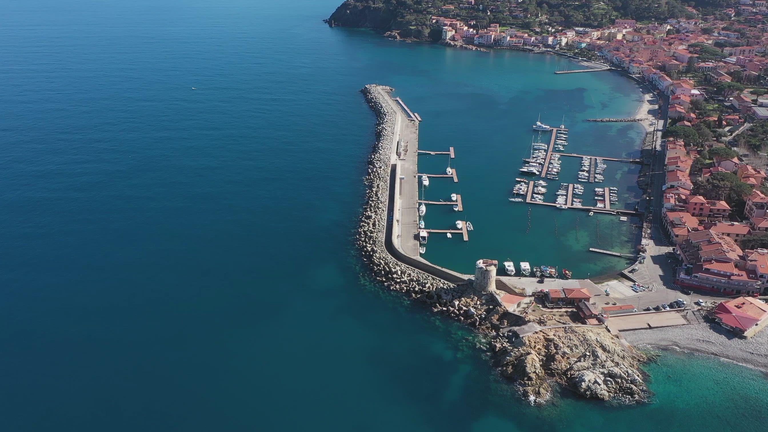
Elba Island , Tuscan Archipelago
- almost 6 years ago
- 418 VŪZ
9 


- 9
- Report

The island of Elba is an island located between the Piombino channel in the east, about 10 kilometers from the coast, the Tyrrhenian sea in the south and the Corsica channel in the west. It is the largest of the islands in the Tuscan archipelago, and the third largest in Italy (223 km²). Elba, together with the other islands of the archipelago (Pianosa, Capraia, Gorgona, Montecristo, Giglio and Giannutri) is part of the Tuscan Archipelago national park. Administratively it is divided into 7 municipalities, part of the province of Livorno. The island of Elba is the largest remaining portion of the ancient stretch of land that connected the Italian peninsula to Corsica, after the other islands of the Tuscan Archipelago. The northern coasts are washed by the Ligurian sea, the eastern ones by the Piombino channel, the southern ones by the Tyrrhenian sea and the western ones by the Corsica channel. The terrain is very varied, and divided into several parts according to its conformation and the geological era in which it was formed: The mountainous and more recent part, to the west, is dominated in the center by the monzogranitic ridge of Monte Capanne (1019 m asl), created about 11 million years ago by means of an underwater lift; inside there are intrusions of porphyritic granite and ophiolite, in the center extends a mostly flat section, interrupted by limestone bas-reliefs. To the east is the oldest part of the island, formed over 400 million years ago. In this hilly area, characterized by schistose and limestone rocks. The climate of the island has mainly Mediterranean features, except for Monte Capanne where the winters tend to be moderately cold. Precipitation is concentrated in the autumn period and appears to be quite contained. The most frequent wind is the sirocco characterized by a high rate of humidity. Modern age The island suffered heavy devastation by Tunisian corsairs in 1442, and subsequently by the hand of Khayr al-Din (Italianized in Ariadeno Barbarossa) in 1534 and 1544 and of Dragut in 1553 and 1555; the cartographic representation of the island in the contemporary Cosmographia by Sebastian Münster testifies to the latter assaults. In 1562 Paolo Giovio wrote: «[Barbarossa] went to the island of Elba, where he had the soldiers dismantled on the ground to do as much prey as possible, because Jacopo d'Appiano, lord of that island and of Piombino, denied making him a Turkish youth son of Sinam known as the Jew, who was already taken in Tunis. Even seeing the ruin that came upon him for this, because the Turks attacked Capolibero and took almost all the terrazzani and they robbed what they could and hunted the inhabitants, made it, and Barbarossa without doing him any more damage then left and sent the young man made captain of seven galleys to Suez, port of the Red Sea very close to Cairo, to his father Sinam; who, for the joy of his son, had immediately died and died. " In 1548 the Grand Duke of Tuscany Cosimo I entrusted the architect Giovanni Camerini with the design of a fortified city symbolically called Cosmopoli (today Portoferraio), conceived as a military garrison with the aim of defending the Tuscan coasts as well as the headquarters of the Knights of Santo Stefano and which in 1583 was described as follows by Giovan Battista Adriani: «The highest hill, which dominates and discovers the whole port, was called the Falcone: the other one taken from the shape of the fortress according to the quality of the site it had the name Stella, spreading its fortifications here and there like rockets. Likewise they stopped a rampart above the mouth of the harbor, which was called by the form Linguella. " In this way the island was divided into three sectors which were politically dependent on Florence (Portoferraio district), Spain with the Presidi State (district of Porto Longone, today Porto Azzurro) and Piombino (all the rest of Elba) . In 1603 the Spaniards of the Presidi State began construction in Porto Azzurro of the fortified nucleus called Forte Beneventano, together with the military garrison of Forte Focardo. At the beginning of the eighteenth century a late follower of Annio da Viterbo wrote a false poem in Latin on the ancient history of Elba set in the sixth century (Rerum mirabilium Ilvae), under the name of Celeteuso. The first general description of the history of the island dates back to 1744 (Zibaldone di memoria) by Giovanni Vincenzo Coresi Del Bruno, governor of Grosseto. Around 1780 Elba was visited by the painter John Robert Cozens, who portrayed panoramas of Porto Azzurro. In 1799 France tried to take possession of the island, with heavy clashes taking place near Procchio. In 1802 Elba became part of the French Empire, and Louis Puissant was commissioned to measure the island and to draw up an accurate cartography with other collaborators. In the same years Elba was visited by several English and French writers who described the island
Up Next
Fetovaia - Elba Island - Tuscan archipelago

- Marco Miele
- 1.3k VŪZ
11 - 18
- almost 6 years ago
Elba Island - May 2024

- Marco Miele
- 1.0k VŪZ
8 - 13
- over 1 year ago
Personal tribute to Marciana Marina - Elba Island -
- Marco Miele
- 1.2k VŪZ
14 - 21
- over 5 years ago
Dronatic Year 2022, relaxing audio and video
- Marco Miele
- 820 VŪZ
5 - 11
- about 3 years ago
Some Mediterranean Islands......
- Marco Miele
- 1.6k VŪZ
6 - 11
- over 3 years ago
THE ISLAND OF ELBA

- ZilverSchmitz
- 2.4k VŪZ
36 - 20
- over 7 years ago
Municipality of Calasetta and its wonders
- Marco Miele
- 1.8k VŪZ
12 - 10
- over 4 years ago
Corno alle Scale area - Emilia Romagna , Italy, January 2021
- Marco Miele
- 952 VŪZ
14 - 14
- almost 5 years ago
Sardinia, The Archipelago of La Maddalena
- Marco Miele
- 1.4k VŪZ
7 - 13
- over 3 years ago
Impressions of Elba

- Travel and Drones
- 817 VŪZ
12 - 11
- about 5 years ago