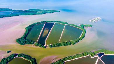
HUALTACO: LAST RELIC OF MANGROVES IN ECUADOR (4K drone video)
- almost 8 years ago
- 219 VŪZ
10 

- 8
- Report

The mangrove is a biome formed by trees very tolerant to the brackish waters of the intertidal zone near the mouth of freshwater courses in tropical and subtropical latitudes. Separated by estuaries that form water channels where the fresh water of the rivers and the salt water of the ocean are mixed. This biome harbors a great biological diversity with high productivity, finding many species of birds, fish, crustaceans, molluscs and others, being an engine of the economy through the use of the existing resources. Its name derives from the trees that form them, mangroves, the word mangle (from which mangrove is derived in German, French and English) comes from a Caribbean voice or Arahuaca, which means twisted tree. They are great barriers that prevent the natural erosion of the ocean, besides being the habitat of numerous species. Unfortunately, the Mangrove is one of the most disturbed biotypes in Ecuador, due to the intense growth of shrimp farms, which have implacably turned large areas of Mangrove forest into small strips that appear to be continuous from the ground, but with the eyes of Quilico , the reality is different. This video shows fragments of a population that has tried to live in harmony with the mangrove, on the Ecuador - Peru border. It is Puerto Hualtaco, located in the Huaquillas county of the province of El Oro. On the Peruvian side is the Manglares de Tumbes National Sanctuary and on the Ecuadorian side, a few communities such as Costa Rica or San Gregorio have bet on ecotourism as an economical activity parallel to fishing. Let's get to know this treasure of Ecuador. Music: Simple Elegance by Alex Arcoleo
Up Next
Middlemost Andes of Ecuador

- QUILICO DRONES
- 2.8k VŪZ
36 - 24
- almost 8 years ago
QUITAHUAYCO: THE INDOMITABLE VALLEY
- QUILICO DRONES
- 2.5k VŪZ
21 - 16
- over 8 years ago
FROM LABRADO TO RASULLANA 4K
- QUILICO DRONES
- 1.1k VŪZ
19 - 14
- almost 8 years ago
Breather in the Sunshine of Tikranaloma
- QUILICO DRONES
- 2.5k VŪZ
26 - 20
- over 8 years ago
LAGARTOCOCHA: IN THE HEART OF CAJAS NATIONAL PARK
- QUILICO DRONES
- 2.2k VŪZ
12 - 16
- over 8 years ago
THE GREAT OSOHUAYCO LAKE
- QUILICO DRONES
- 1.8k VŪZ
12 - 13
- over 8 years ago
YANAURCO PEAK: CAJAS NATIONAL PARK INSIGNIA
- QUILICO DRONES
- 1.2k VŪZ
18 - 13
- over 8 years ago
PLAYAS ENCANTADAS (ENCHANTED SHORES)
- QUILICO DRONES
- 837 VŪZ
18 - 13
- over 8 years ago
ARQUITECTOS: HIGHEST SUMMIT OF CAJAS NATIONAL PARK
- QUILICO DRONES
- 1.4k VŪZ
11 - 11
- over 8 years ago
EL CAJAS: MEMORIES OF A HIKER
- QUILICO DRONES
- 980 VŪZ
14 - 7
- over 7 years ago