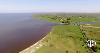
Lough Neagh shore Line Derrytrasna N.Ireland
- over 8 years ago
- 108 VŪZ
4 


- 3
- Report
So the weather has been great all week and I had to take a trip to the Lough and shoot some footage. First of all I give a call to Aldergrove airport tower (EGAA) for clearance as the area I was going to be flying in has a control zone from 400 feet as landing planes fly over the lough to land at the airport on the north side. (safety first always)
I start off at a place called the Bannfoot, it is where the river Bann joins the lough on the south east side and just where the river enters the lough you will notice a road on either side of the river. There used to be a man that would use ropes to pull over a platform so people could cross the river but that was a long time ago. It is so funny that these two roads are so close together but if you want to driver to the other side it would take almost 30 mins to drive https://www.google.co.uk/maps/dir/54.5047849,-6.5174766/54.5042803,-6.5186461/@54.465877,-6.5521469,12z/data=!3m1!4b1!4m2!4m1!3e0
You will notice as well in this video that there are many flys lol this is common for this area and often enough they buzz around is huge black clouds. Also the Wilde life on the Lough is plentiful as you can see the many different birds that choose to live here from as far as Canada, Iceland, Greenland and the Russian Arctic.
The lough is also home to eels. The eels in Lough Neagh travel over 4000 miles to breed in the Sargasso Sea and the young fry return by drifting on the Gulf Stream back over the Atlantic and enter the River Bann as young elvers
Lastly the Lough is one of the main sources of sand for the area, massive boats suck up sand from the bottom of the lough and then bring it to shore to be sold to building sites though out the country. There is an ongoing debate with locals that feel this is damaging the landscape and wild life.
Hope you enjoy the video and history of the area.
Up Next
Lough Tay, The Guinness Lake. Ireland. Mavic 2 pro

- Mark's Mavic 2
- 1.8k VŪZ
31 - 21
- about 7 years ago
St Patrick's Purgatory, Lough Derg, Ireland. Cinematic 4K Drone Footage.
- Mark's Mavic 2
- 792 VŪZ
12 - 9
- almost 5 years ago
Low flight along the shore line of Cannon Beach

- DroneCLT
- 959 VŪZ
14 - 12
- over 9 years ago
California Coastline
- Tadingle
- 738 VŪZ
12 - 12
- about 7 years ago
River Roe & Lough FoyleRiver Roe & Lough Foyle

- imaginelight
- 1.6k VŪZ
15 - 13
- over 7 years ago
Brittany's Côte de Granit-Rose

- PAMaire
- 1.2k VŪZ
10 - 11
- over 7 years ago
Gad tower in Lough Erne

- Peter and Loki
- 1.1k VŪZ
13 - 13
- over 5 years ago
Ireland - Lough Gur Historic Droning

- seb-depp
- 710 VŪZ
3 - 1
- over 2 years ago
Fly Over Donegal, Ireland. Glenveagh National Park, Doe Castle, Mount Errigal, Dunlewey Church. 4K.
- Mark's Mavic 2
- 754 VŪZ
14 - 11
- almost 5 years ago
Carlingford and King John's Castle. Ireland. Mavic 2 Pro.
- Mark's Mavic 2
- 1.1k VŪZ
14 - 9
- about 7 years ago