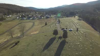
DJI Inspire 1 Drone at Rest Lawn Memorial Gardens, Cash Valley, GAP Trail (Cumberland) Maryland 4k
- about 8 years ago
- 53 VŪZ
0 - 0
- Report
Flying from the Rest Lawn Memorial Gardens off of Cash Valley Road near Cumberland, Maryland. Aside from the Memorial Gardens, you can see the Great Allegheny Passage (G.A.P.) Trail, Helmstetter's Farm and the Horseshoe Curve. One of the most famous railroad landmarks east of the Mississippi River is the Western Maryland's Helmstetter's Curve located just west of Cumberland on the system's former Connellsville Subdivision. As the company expanded westward in the early 20th century it had to find a relatively manageable gradient through the Allegheny Mountains which quickly rose once one was out of the Potomac River valley. With newer engineering techniques, surveyors would ultimately plot a line that was somewhat easier than neighbor and competitor Baltimore & Ohio's Sand Patch grade. The curve became so well photographed over the years thanks to the generosity of the local family who owns the surrounding property and whose name is attached to it. You can also get a glimpse of Cash Valley Elementary School which is near the Memorial Gardens. I am not standing or landing on any graves, and by the tractor tracks you can be sure.
Up Next
Fall in the Mad River Valley Vermont

- Jturner
- 5.5k VŪZ
15 - 13
- about 5 years ago
Teignmouth Colour Rush Charity Event

- ccaerialsolutions
- 1.2k VŪZ
12 - 16
- over 8 years ago
Truckee River, Alpine Meadows, Lake Tahoe DJI Mavic Pro

- briansolis
- 4.8k VŪZ
23 - 10
- almost 9 years ago
Westcoast Winter Series | Cascade Falls

- indentmedia
- 3.1k VŪZ
37 - 31
- almost 9 years ago
WOW! Look at this amazing Shoot | DJI Mavic | Austria | Lungau

- 4KDrone
- 1.4k VŪZ
33 - 35
- almost 8 years ago
Mcleans Pass - Gardens of Stone - Australia

- Tim Harris
- 2.3k VŪZ
28 - 26
- almost 8 years ago
A short journey through BC

- Aerial Eye Visuals
- 1.2k VŪZ
29 - 19
- over 7 years ago
Temple of Doom - Gardens of Stone - Australia
- Tim Harris
- 3.2k VŪZ
38 - 27
- almost 8 years ago
A Foggy Morning (Schubert Ave Maria)

- ibrahimer
- 1.1k VŪZ
12 - 17
- about 5 years ago
Monserrate Palace In Sintra, UNESCO Heritage since 1992

- flymydr8ne
- 1.1k VŪZ
15 - 19
- about 6 years ago