Interested In This Footage?
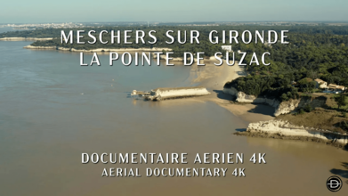
Meschers sur Gironde, La Pointe de Suzac
AIRVŪZ STAFF NOTE :
The Gironne River is one of the most important waterways in western France. It runs a length of about 330 mi. (around 530 km) before emptying into a giant (eponymous) estuary just past the port city of Bordeaux. In this drone video by AirVuz contributor DRHON-EL, you'll get an aerial view of the Gironne Estuary in the commune of Meschers-sur-Gironde, which lies on the eastern side of the estuary a short distance south of where the estuary empties into the Bay of Biscay (an inlet of the Atlantic Ocean) in the Charente-Maritime Department.
- over 3 years ago
- 455 VŪZ
9 


- 7
- Report
BADGES THIS VIDEO HAS EARNED:

The limestone cliffs of the Michelaise coast and its troglodyte dwellings are typical of the region. The "Pointe de Suzac" extends this rocky line.
Up Next
Autoplay
The Cordouan LightHouse

- DRHON-EL
- 540 VŪZ
3 - 2
- over 2 years ago
La Trinité-sur-Mer
- DRHON-EL
- 879 VŪZ
6 - 6
- about 2 years ago
La Citadelle de Blaye
- DRHON-EL
- 1.9k VŪZ
3 - 2
- about 3 years ago
La Rochelle
- DRHON-EL
- 1.3k VŪZ
9 - 6
- over 2 years ago
Château de Pressac
- DRHON-EL
- 1.2k VŪZ
5 - 5
- about 3 years ago
Saint Cado, La Ria d'Etel
- DRHON-EL
- 543 VŪZ
2 - 0
- over 3 years ago
The Cross and the Light: Soaring Over Pointe-de-la-Croix at Les Escoumins

- Cricrou FPV
- 1.0k VŪZ
0 - 0
- almost 2 years ago
La Tremblade
- DRHON-EL
- 1.1k VŪZ
5 - 3
- over 2 years ago