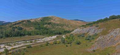
Naturalistic area of the valley of the Sillaro stream
- almost 3 years ago
- 72 VŪZ
4 


- 2
- Report

The Sìllaro (Sèlar in Romagna, Séller in Bolognese dialect, known to the Romans as Sillarus) is an important stream in Emilia-Romagna, a tributary of the Reno, which flows through the territory of several provinces: the source and the first 4 km are in the city underground of Florence, then most of its course is in the metropolitan city of Bologna; after traveling 1 km in the municipality of Conselice (province of Ravenna), the last 6.5 km are in the municipality of Argenta (province of Ferrara). It also performs the function of an important water collector of many other streams and its course also represents the historical-geographical border between Emilia and Romagna. Born at the foot of Mount Tre Poggioli (966 m.s.l.m.), in the municipality of Firenzuola. After a few kilometers it enters Emilia-Romagna at Giugnola (a hamlet divided between the municipalities of Firenzuola and Castel del Rio) and runs through a valley characterized by calanchiferous formations. In the middle Apennine stretch it receives the Acquabona stream from the right while from the left two small but impetuous streams, the rio Sassuno and the rio Ronco, both born in the mountainous complex of Monte Grande. It skirts the city of Castel San Pietro Terme: here the Canale di Medicina branches off from the stream. In its flat stretch the Sillaro receives from the right, near Castel Guelfo di Bologna, its two main tributaries, namely the Rio Sabbioso and the Sellustra stream. Subsequently bathes Sesto Imolese and enters the municipality of Conselice, in the province of Ravenna, for a short distance. From here, diverted into an artificial riverbed following the reclamation works in modern times, it heads north and enters the territory of the municipality of Argenta, in the province of Ferrara. From this moment its course marks the border between the provinces of Ravenna and Ferrara, in which the Sillaro becomes part of the Campotto Valleys (a detached section of the Po Delta Regional Park), feeding, with its waters in excess, the Valle Santa expansion bank. Shortly after having lapped its fill box, it concludes its course (66 km) flowing from the right into the Reno river in La Bastia, between Lavezzola and San Biagio di Argenta; its confluence occurs practically together with that of the Idice torrent, which is also a tributary of the Reno.
Up Next
Lake Toblino, its Vineyards, its Castle

- Marco Miele
- 812 VŪZ
8 - 11
- over 1 year ago
The twilight on the Dolomites, the Valley Pusteria in the area of Terento
- Marco Miele
- 958 VŪZ
10 - 14
- over 4 years ago
The lakes of Sant'Anna in San Cesario sul Panaro, Modena , Emilia Romagna , Italy
- Marco Miele
- 533 VŪZ
0 - 0
- over 2 years ago
Sardinia, Stintino - Asinara Island Naturalistic and Marine park
- Marco Miele
- 1.4k VŪZ
10 - 18
- almost 2 years ago
Spring on the Po Valley
- Marco Miele
- 715 VŪZ
10 - 10
- about 1 year ago
The Beech Forests of Frignano in winter
- Marco Miele
- 1.9k VŪZ
8 - 12
- about 1 year ago
The Emilia-Romagna Hills in the Dozza-Imolese Area
- Marco Miele
- 561 VŪZ
12 - 10
- over 5 years ago
Regional Park of Gessi Bolognesi and Calanchi dell'Abbadessa
- Marco Miele
- 789 VŪZ
12 - 18
- over 3 years ago
Campo Imperatore and the Gran Sasso mountain range - east side
- Marco Miele
- 833 VŪZ
7 - 10
- over 3 years ago
Ancient village of Montorio - fraction of Monzuno (Bologna)
- Marco Miele
- 1.1k VŪZ
14 - 16
- about 4 years ago